IMAGES TAKEN NEAR TO
Woodvale Walk, LONDON, SE27 0EY
Introduction
This page details the photographs taken nearby to Woodvale Walk, SE27 0EY by members of the Geograph project.
The Geograph project started in 2005 with the aim of publishing, organising and preserving representative images for every square kilometre of Great Britain, Ireland and the Isle of Man.

There are currently over 7.5m images from over14,400 individuals and you can help contribute to the project by visiting https://www.geograph.org.uk
Image Map
Images are licensed for reuse under creativecommons.org/licenses/by-sa/2.0
Notes
- Clicking on the map will re-center to the selected point.
- The higher the marker number, the further away the image location is from the centre of the postcode.
Image Listing (80 Images Found)
Images are licensed for reuse under creativecommons.org/licenses/by-sa/2.0
Image
Details
Distance
2
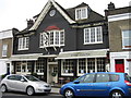
Maudsley Cottages, Elder Road
A "very modest" terrace (Pevsner) within the Elderwood Road Conservation Area. The houses are thought to have been built around 1855, while the pub dates from the 1920s. Lambeth Council's conservation paper comments that "they contribute in group value to the area as a whole and provide an excellent village-scale foil to the larger buildings.
Image: © Stephen Richards
Taken: Unknown
0.05 miles
3
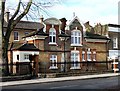
Lodge, Elder Road
The lodge to Elderwood (Image). It was built in 1887, possibly to the designs of Sidney Smith. With its shaped gables and decorative plasterwork it's a jolly little building. It is within the Elderwood Road Conservation Area. In its planning paper Lambeth council described it as an "Outdoor Relief Station" which makes it sound a bit like a public toilet.
Image: © Stephen Richards
Taken: Unknown
0.06 miles
4
Elderwood, Elder Road
Built as a school house for the House of Industry for the Infant Poor which was established here in 1810. Grade II listed.
Writing in 1983, Pevsner observed that the building's future was uncertain, but having been converted into flats it now seems safe. It is within the Elderwood Road Conservation Area.
Image: © Stephen Richards
Taken: Unknown
0.06 miles
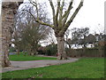
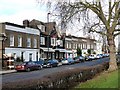
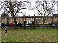
9
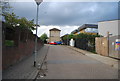
Norwood Park
From the path shown in Image, this looks across the line of view of Image and includes Elderwood http://list.english-heritage.org.uk/resultsingle.aspx?uid=1184933&searchtype=mapsearch , the housing shown in Image On the right is a fenced multi-purpose sports court.
Image: © Derek Harper
Taken: 9 May 2013
0.10 miles