IMAGES TAKEN NEAR TO
Broxholm Road, LONDON, SE27 0BT
Introduction
This page details the photographs taken nearby to Broxholm Road, SE27 0BT by members of the Geograph project.
The Geograph project started in 2005 with the aim of publishing, organising and preserving representative images for every square kilometre of Great Britain, Ireland and the Isle of Man.

There are currently over 7.5m images from over14,400 individuals and you can help contribute to the project by visiting https://www.geograph.org.uk
Image Map (Loading...)


Getting Data...Please wait
Leaflet Map data © OpenStreetMap
Images are licensed for reuse under creativecommons.org/licenses/by-sa/2.0
Notes
- Clicking on the map will re-center to the selected point.
- The higher the marker number, the further away the image location is from the centre of the postcode.
Image Listing (26 Images Found)
Images are licensed for reuse under creativecommons.org/licenses/by-sa/2.0
Image
Details
Distance
1
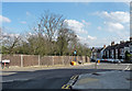
Royal Circus
Bath and Edinburgh may have better known examples, but their charms are obvious whereas West Norwood's requires an exercise of the imagination to fully appreciate its (potential) splendour.
Standing on high ground, it should have been the circular hub of a prestigious early Victorian development from which villa-lined roads would radiate, but it flopped and the surrounding houses are routine Victorian and early C20th fare. Behind the wooden fence is Tonge House, originally a "home for ladies", almshouses established by Bertha Portal, the present building also early C20th by the looks of it.
Image: © Stephen Richards
Taken: 17 Feb 2013
0.10 miles
2
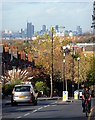
View down Knight's Hill (2)
A number of prominent buildings in central London are visible.
The tower under construction (above the car) is Strata, a block of flats at Elephant Castle (2007-10, by Hamilton's Architects).
Immediately to its left can be seen the dome of St Paul's Cathedral.
To its right can be seen the three Barbican towers - Cromwell, Shakespeare, and Lauderdale (1965-76, Chamberlin, Powell and Bon).
Pity the poor cyclist. He didn't even notice me standing in his way.
Image: © Stephen Richards
Taken: Unknown
0.10 miles
4
Canterbury Grove
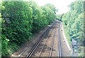
The road descends towards Norwood Road, although it is interrupted by the railway which is crossed only by a footbridge.
The distant woods might be near Dulwich golf course.
Image: © Stephen Richards
Taken: 21 Apr 2012
0.16 miles
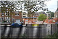
7
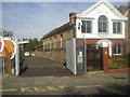
Hitherfield Road Baptist Church and entrance to Hitherfield Primary School
A house on the site of Hitherfield Road Baptist Church was purchased in 1902 and demolished in 1906. The foundation stone laying ceremony of the church was held on 7th December 1906, and the opening ceremony on 25th April, 1907. To the left of the church is the entrance to Hitherfield Primary School.
Image: © Marathon
Taken: 1 Sep 2010
0.19 miles
8
Hitherfield Primary School and Hitherfield Road Baptist Church
Hitherfield Primary School extends from Hitherfield Road as far as the railway line between Streatham Hill and West Norwood. Hitherfield Road Baptist Church was opened in 1907 on the site of a previously demolished house. See also https://www.geograph.org.uk/photo/2064883
Image: © Marathon
Taken: 1 Sep 2010
0.19 miles
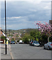
9
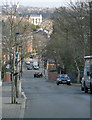
York Hill
Running from the high ground north-east towards Norwood Road at the bottom, Lancaster Avenue the continuation beyond.
Image: © Stephen Richards
Taken: 17 Feb 2013
0.19 miles
10
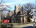
St Peter, Leigham Court Road
Built of polychromatic brick - rather fashionable at the time - in 1870 by R.W. Drew, with some later work by G.H. Fellowes Prynne in 1886-87. Grade II* listed.
Image: © Stephen Richards
Taken: Unknown
0.19 miles