IMAGES TAKEN NEAR TO
Talisman Square, LONDON, SE26 6XZ
Introduction
This page details the photographs taken nearby to Talisman Square, SE26 6XZ by members of the Geograph project.
The Geograph project started in 2005 with the aim of publishing, organising and preserving representative images for every square kilometre of Great Britain, Ireland and the Isle of Man.

There are currently over 7.5m images from over14,400 individuals and you can help contribute to the project by visiting https://www.geograph.org.uk
Image Map
Images are licensed for reuse under creativecommons.org/licenses/by-sa/2.0
Notes
- Clicking on the map will re-center to the selected point.
- The higher the marker number, the further away the image location is from the centre of the postcode.
Image Listing (78 Images Found)
Images are licensed for reuse under creativecommons.org/licenses/by-sa/2.0
Image
Details
Distance
1
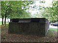
Ventilation shaft, Sydenham Hill tunnel
This concrete box is a ventilation shaft for a railway tunnel which passes beneath this point. The housing estate which surrounds this shaft was built over the site of another railway which closed in 1954.
Image: © Malc McDonald
Taken: 17 Oct 2010
0.04 miles
2
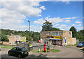
Local Store, High Level Drive
Convenience store for a housing estate.
The unusual road name is from a disused rail tunnel that goes underneath here.
It served Crystal Palace High Level station before it closed in 1954.
Image: © Des Blenkinsopp
Taken: 9 Aug 2016
0.11 miles
3
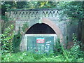
Paxton Tunnel, north portal
Part of the Crystal Palace and South London Junction Railway http://en.wikipedia.org/wiki/Crystal_Palace_and_South_London_Junction_Railway See Image for the other end of this tunnel. See Image for the south portal (identical to this one) of the Crescent Wood Tunnel.
Image: © Roger W Haworth
Taken: 20 Aug 2011
0.14 miles

5
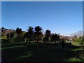
Sydenham Wells Park (2)
The park is the sole remaining relic of Sydenham Common, and its name a reference to the springs first discovered in the C17th.
Image: © Stephen Richards
Taken: 30 Nov 2014
0.15 miles
9
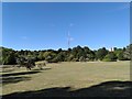
Site of Upper Sydenham Station
There is little in this picture to give away that it was once a railway station, although if you look very closely, you might just make out part of a tunnel entrance through the trees in the centre of the image.
The railway was a branch line from Nunhead to Crystal Palace High Level station. The Crystal Palace itself was destroyed by fire in 1936, but the branch line struggled on, with few passengers, finally closing in 1954. Housing has been built over some parts of the route but nature has reclaimed the site of Upper Sydenham station. There are photos of the station on the 'Disused Stations' website, at
http://www.disused-stations.org.uk/u/upper_sydenham/index.shtml
Image: © Malc McDonald
Taken: 17 Oct 2010
0.16 miles
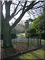
10
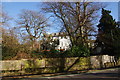
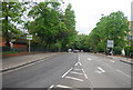
Large houses on Sydenham Hill
Looking uphill from Fountain Drive.
Image: © Bill Boaden
Taken: 1 Feb 2014
0.16 miles