IMAGES TAKEN NEAR TO
Crescent Wood Road, LONDON, SE26 6SB
Introduction
This page details the photographs taken nearby to Crescent Wood Road, SE26 6SB by members of the Geograph project.
The Geograph project started in 2005 with the aim of publishing, organising and preserving representative images for every square kilometre of Great Britain, Ireland and the Isle of Man.

There are currently over 7.5m images from over14,400 individuals and you can help contribute to the project by visiting https://www.geograph.org.uk
Image Map
Images are licensed for reuse under creativecommons.org/licenses/by-sa/2.0
Notes
- Clicking on the map will re-center to the selected point.
- The higher the marker number, the further away the image location is from the centre of the postcode.
Image Listing (94 Images Found)
Images are licensed for reuse under creativecommons.org/licenses/by-sa/2.0
Image
Details
Distance
4
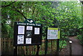
Information at the entrance to Sydenham Hill Wood
Image: © N Chadwick
Taken: 9 May 2010
0.06 miles
5
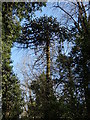
Garden remnant in Sydenham Hill Wood
The eastern slopes of Sydenham Hill Wood were once the gardens of large Victorian villas built after the Crystal Palace was relocated to upper Sydenham. These houses soon fell into decline and by the second world war were subdivided into flats or had been taken over as institutions like care homes. They were demolished from the 60s onwards and their grounds have reverted to woodland. However, look carefully and there are remnants of the gardens, like this monkey puzzle tree, now grown tall to reach the light in competition with the native trees surrounding it.
Image: © Brian Whittle
Taken: 25 Mar 2020
0.07 miles
6
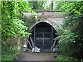
Crescent Wood Tunnel Entrance, Sydenham Hill Wood
Northern portal of the Crescent Wood Tunnel which is 429yds long. The line was the Nunhead to Crystal Palace (High Level), which closed in 1954. See http://www.subbrit.org.uk/tunnelbase/sites/p/paxton/index.shtml at Subterranea Britanica. The inner gates bear the name of the London Wildlife Trust who have created a bat roost within the tunnel - http://www.wildlondon.org.uk/Portals/0/News/tabid/71/mid/414/newsid414/128/Default.aspx . See: Image for the southern portal of this tunnel and Image for the Paxton Tunnel.
Image: © Roger W Haworth
Taken: 20 Aug 2011
0.07 miles
7
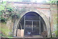
Crescent Wood Tunnel Entrance, Sydenham Hill Wood
The Crescent Wood Tunnel is 429yds long. The line was the Nunhead to Crystal Palace (High Level), which closed in 1954. See http://www.subbrit.org.uk/tunnelbase/sites/p/paxton/index.shtml at Subterranea Britannica. The inner gates bear the name of the London Wildlife Trust who have created a bat roost within the tunnel - http://www.wildlondon.org.uk/Portals/0/News/tabid/71/mid/414/newsid414/128/Default.aspx .
Image: © N Chadwick
Taken: 9 May 2010
0.07 miles
8
Sydenham Hill Woods
Crescent Wood Tunnel, located just north of the Crystal Palace Park, in Sydenham Hill Woods. The Crystal Palace and South London Junction Railway ran from Nunhead to Crystal Palace High Level; opened in 1865, finally closed in 1954.
The woods are managed by the London Wildlife Trust.
Image: © Peter Trimming
Taken: 20 Sep 2017
0.07 miles
9
Sydenham Hill Woods
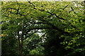
Tree canopy above the tunnel entrance of the former Crystal Palace and South London Junction Railway, which ran from Nunhead to Crystal Palace High Level; opened in 1865, finally closed in 1954.
The woods are managed by the London Wildlife Trust.
Image]
Image: © Peter Trimming
Taken: 20 Sep 2017
0.07 miles
10
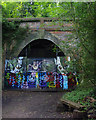
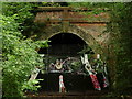
Crescent Wood Tunnel
In Sydenham Hill Wood. The north portal on the dismantled Crystal Palace and South London Junction Railway (Nunhead to Crystal Palace High Level) which closed in 1954.
Now used as a bat roost.
Image: © Ian Taylor
Taken: 11 Aug 2019
0.07 miles