IMAGES TAKEN NEAR TO
Wells Park Road, LONDON, SE26 6RQ
Introduction
This page details the photographs taken nearby to Wells Park Road, SE26 6RQ by members of the Geograph project.
The Geograph project started in 2005 with the aim of publishing, organising and preserving representative images for every square kilometre of Great Britain, Ireland and the Isle of Man.

There are currently over 7.5m images from over14,400 individuals and you can help contribute to the project by visiting https://www.geograph.org.uk
Image Map
Images are licensed for reuse under creativecommons.org/licenses/by-sa/2.0
Notes
- Clicking on the map will re-center to the selected point.
- The higher the marker number, the further away the image location is from the centre of the postcode.
Image Listing (91 Images Found)
Images are licensed for reuse under creativecommons.org/licenses/by-sa/2.0
Image
Details
Distance
1
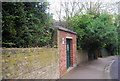
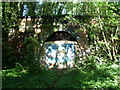
Electrical transformer shed, Wells Park Rd
Image: © N Chadwick
Taken: 9 May 2010
0.01 miles
2
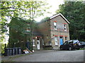
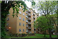
Upper Sydenham former railway station
This building was originally a railway station. Upper Sydenham station opened in 1884, on the branch line to Crystal Palace High Level. This line was never very successful and was closed in 1954. The station house has been converted into flats.
More information about Upper Sydenham station is given on the Disused Stations website at http://www.disused-stations.org.uk/u/upper_sydenham/index.shtml
Image: © Malc McDonald
Taken: 17 Oct 2010
0.02 miles
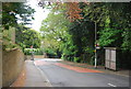
6
Site of Upper Sydenham station
The London, Chatham & Dover Railway opened the line from Nunhead to Crystal Palace High Level in 1865 to serve the Crystal Palace, which had been rebuilt on Sydenham Hill some ten years previously. Unfortunately the Crystal Palace was in decline as a visitor attraction by the end of the 19th century and this, coupled with the fact that the line passed through an area which was largely undeveloped well into the 20th century, meant that the line had very low passenger usage. It finally closed in 1954. There were two tunnels on the line. This is the south portal of Crescent Wood Tunnel which is the northern one of the two. Upper Sydenham station stood here immediately next to the tunnel entrance, but not a trace of it now remains. It did not open until 1884 but its passenger numbers were always minimal so that even in the 1920s, only some 400 people per day were using the station, and probably most of these were being double-counted as they were making return journeys. More information about Upper Sydenham station can be found at http://www.disused-stations.org.uk/u/upper_sydenham/index.shtml
The northern portal of Crescent Wood Tunnel can be seen at http://www.geograph.org.uk/photo/2635008
Image: © Marathon
Taken: 21 Sep 2011
0.06 miles
7
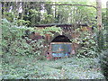
Closed railway tunnel, Upper Sydenham
This was once a railway line. The branch line to Crystal Palace High Level passed through the tunnel. The line was never very successful and when the Crystal Palace itself was destroyed by fire in 1936, the fate of the branch line was sealed. It struggled on until closure in 1954. The tunnel mouth at the former Upper Sydenham station is one of a number of relics of the railway which can still be seen today, more than half a century since the last train ran.
The 'Disused Stations' website http://www.disused-stations.org.uk/u/upper_sydenham/index.shtml has pictures of this site when the railway was still running.
Image: © Malc McDonald
Taken: 17 Oct 2010
0.07 miles
9
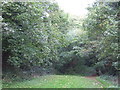
Site of Upper Sydenham Station
There is little in this picture to give away that it was once a railway station, although if you look very closely, you might just make out part of a tunnel entrance through the trees in the centre of the image.
The railway was a branch line from Nunhead to Crystal Palace High Level station. The Crystal Palace itself was destroyed by fire in 1936, but the branch line struggled on, with few passengers, finally closing in 1954. Housing has been built over some parts of the route but nature has reclaimed the site of Upper Sydenham station. There are photos of the station on the 'Disused Stations' website, at
http://www.disused-stations.org.uk/u/upper_sydenham/index.shtml
Image: © Malc McDonald
Taken: 17 Oct 2010
0.07 miles
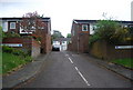
10
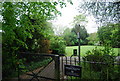
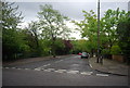
Wells Park Road entrance to Sydenham Wells Park
Image: © N Chadwick
Taken: 9 May 2010
0.07 miles