IMAGES TAKEN NEAR TO
Westwood Hill, LONDON, SE26 6NW
Introduction
This page details the photographs taken nearby to Westwood Hill, SE26 6NW by members of the Geograph project.
The Geograph project started in 2005 with the aim of publishing, organising and preserving representative images for every square kilometre of Great Britain, Ireland and the Isle of Man.

There are currently over 7.5m images from over14,400 individuals and you can help contribute to the project by visiting https://www.geograph.org.uk
Image Map
Images are licensed for reuse under creativecommons.org/licenses/by-sa/2.0
Notes
- Clicking on the map will re-center to the selected point.
- The higher the marker number, the further away the image location is from the centre of the postcode.
Image Listing (121 Images Found)
Images are licensed for reuse under creativecommons.org/licenses/by-sa/2.0
Image
Details
Distance
1
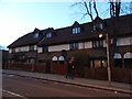
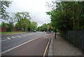
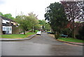
Houses on Westwood Hill, Upper Sydenham
On the northern edge of Crystal Palace
Image: © David Howard
Taken: 16 Feb 2014
0.02 miles
2
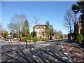
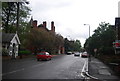
Crystal Palace, Torrington Court
Apartment block at the junction of Crystal Palace Park Road and Westwood Hill.
Image: © Mike Faherty
Taken: 20 Apr 2013
0.03 miles
3
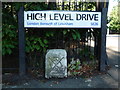
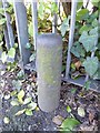
High Level Bridge Mark
High Level Drive, SE26 street name at the junction with Westwood Hill. This was probably the vehicular entrance to Upper Sydenham railway station (Image). Confusingly, Crystal Palace High Level railway station (Image) was about a kilometre away to the southwest. Wikipedia on the railway line: http://en.wikipedia.org/wiki/Crystal_Palace_and_South_London_Junction_Railway . The boundary stone below it bears the Bridge Mark http://en.wikipedia.org/wiki/Bridge_House_Estates#Logo , the logo of Bridge House Estates, a charitable trust originally established to maintain the bridges in the City of London. Clearly near here is part of the Trust's extensive property portfolio. The stone may well be 300 years old.
Image: © Roger W Haworth
Taken: 20 Aug 2011
0.03 miles
4
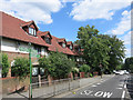
Green Chain Walk on Westwood Hill
The Green Chain Walk links parks and open spaces in South East London.
This is one of the trademark green signposts on the section between Sydenham Wells and Crystal Palace Parks.
Image: © Des Blenkinsopp
Taken: 9 Aug 2016
0.04 miles
6
Old Boundary Marker by the A212, Westwood Hill, Lewisham and Blackheath parish
Parish Boundary Marker by the A212, in parish of Lewisham and Blackheath (Lewisham District), Westwood Hill SE26, East of park entrance against railings.
Surveyed
Milestone Society National ID: KE_LEW04pb
Image: © Milestone Society
Taken: Unknown
0.08 miles
8
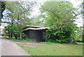
Derelict looking toilet block, Crystal Palace Park
Image: © N Chadwick
Taken: 9 May 2010
0.09 miles
10
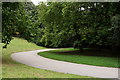
Crystal Palace Park
When motor racing events took place around the Crystal Palace circuit, this bend was at the end of the start/finish straight, before the cars entered the downhill section. From memory, the track was almost twice as wide at the point, with the inside of the bend now filled in with grass.
Most of the top drivers raced here, including several F1 world champions. I recall seeing Graham Hill, John Surtees, Jochen Rindt and Jody Scheckter driving in the F2 events. In the final full season (1972), the lap record of 103.39 mph was set by Mike Hailwood. On a tight and twisty circuit, saloon car racing was particularly entertaining.
The longest race which I witnessed was an F2 final, at 125 laps. A 50 lap F2 final was more usual.
As might have been expected, there were accidents, as most races were 10 or 15 lap 'sprints'. During one F3 race, a Lotus entered the start/finish straight when suddenly all four wheels came off the car ... this was several laps into the event, and the accident happened at about the safest point on the circuit.
Image: © Peter Trimming
Taken: 20 Sep 2017
0.10 miles