IMAGES TAKEN NEAR TO
Mount Ash Road, LONDON, SE26 6LZ
Introduction
This page details the photographs taken nearby to Mount Ash Road, SE26 6LZ by members of the Geograph project.
The Geograph project started in 2005 with the aim of publishing, organising and preserving representative images for every square kilometre of Great Britain, Ireland and the Isle of Man.

There are currently over 7.5m images from over14,400 individuals and you can help contribute to the project by visiting https://www.geograph.org.uk
Image Map
Images are licensed for reuse under creativecommons.org/licenses/by-sa/2.0
Notes
- Clicking on the map will re-center to the selected point.
- The higher the marker number, the further away the image location is from the centre of the postcode.
Image Listing (66 Images Found)
Images are licensed for reuse under creativecommons.org/licenses/by-sa/2.0
Image
Details
Distance
1
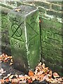
Boundary marker
A boundary stone on the footpath connecting Kirkdale with Lammas Green Estate. It marks land owned the Bridge House charity, established in 1282 by the City of London. Lammas Green Estate is owned by the City but located in the London Borough of Lewisham.
Image: © Brian Whittle
Taken: 10 Nov 2020
0.09 miles
2
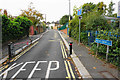
Kelvin Grove
A narrow residential road on the eastern side of Sydenham Hill.
Image: © Bill Boaden
Taken: 10 Oct 2015
0.09 miles
3
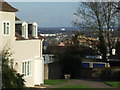
Lammas Green view
View looking southeastwards from Lammas Green
Image: © Malc McDonald
Taken: 4 Apr 2010
0.09 miles
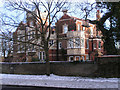
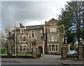
4
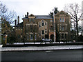
The Cedars
One of the few remaining Victorian piles on Sydenham Hill. The Cedars was built in 1894 for Charles Ash Body.
Image: © Brian Whittle
Taken: 26 Dec 2010
0.09 miles
5
34a Sydenham Hill
Another of the surviving Victorian Mansions which one lined this road. There are few left now.The neighbouring mansion to this, The Cedars is probably the most attractive.
Image: © Brian Whittle
Taken: 26 Dec 2010
0.10 miles
6
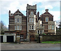
34a Sydenham Hill
One of the larger Victorian villas to survive on this road. A typical Victorian array of motifs but, to borrow Pevsner's word, ponderous.
Now flats.
Image: © Stephen Richards
Taken: 14 Feb 2013
0.11 miles
7
Lammas Green
Tucked just off Sydenham Hill, the Corporation of London housing estate at Lammas Green is Grade II listed.
Image: © Malc McDonald
Taken: 4 Apr 2010
0.11 miles
8
Detail of 34 Sydenham Hill
Terracotta detail on this building: Image A panel bears the initials CAB (for Charles Ash Body) and the date 1898.
Image: © Stephen Richards
Taken: 14 Feb 2013
0.12 miles
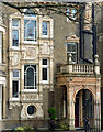
9
34 Sydenham Hill
Aka 'The Cedars'. One of the larger Victorian villas to survive on this road. Generous use of terracotta (Image]).
Home to the Salvation Army International College for Officers and Centre for Spiritual Life Development.
Image: © Stephen Richards
Taken: 14 Feb 2013
0.12 miles
10
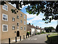
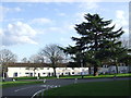
Lammas Green, Dulwich
Lammas Green was built in the late 1950s and is Grade II listed. It comprises 27 cottage type houses and 30 three and four bedroom flats.
It is run by the City of London rather than Southwark, the local authority.
The City crest can be seen above the arch on the left.
Image: © Des Blenkinsopp
Taken: 9 Aug 2016
0.13 miles