IMAGES TAKEN NEAR TO
The Parade, Wells Park Road, LONDON, SE26 6JD
Introduction
This page details the photographs taken nearby to The Parade, Wells Park Road, SE26 6JD by members of the Geograph project.
The Geograph project started in 2005 with the aim of publishing, organising and preserving representative images for every square kilometre of Great Britain, Ireland and the Isle of Man.

There are currently over 7.5m images from over14,400 individuals and you can help contribute to the project by visiting https://www.geograph.org.uk
Image Map
Images are licensed for reuse under creativecommons.org/licenses/by-sa/2.0
Notes
- Clicking on the map will re-center to the selected point.
- The higher the marker number, the further away the image location is from the centre of the postcode.
Image Listing (76 Images Found)
Images are licensed for reuse under creativecommons.org/licenses/by-sa/2.0
Image
Details
Distance
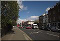
1
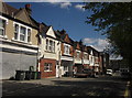
The Parade, Wells Park Road
A series of gables along the final stretch of the road before it meets the A2216 Kirkdale. Many of the building house flats, though some seem to operate as businesses, including a painting firm. I think this used to be a row of shops.
Image: © Derek Harper
Taken: 9 May 2013
0.01 miles
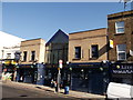
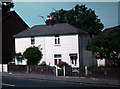
2
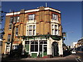
Foxes Public House, Upper Sydenham
On the junction of Wells Park Road (in front) and Kirkdale (on the right).
No.146 of the terrace of 5 listed buildings. Was once called Fox and Hounds.
See http://www.britishlistedbuildings.co.uk/en-504488-high-street-buildings-134-146-lewisham for more details about the listed terrace.
Image: © David Anstiss
Taken: 2 Oct 2011
0.03 miles
3
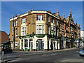
Fox's, Sydenham
Previously the Fox and Hounds.
Image: © Robin Webster
Taken: 1 Oct 2011
0.03 miles
4
High Street Buildings
The name is helpfully displayed half way up the central part, but there is no sign of a date.
Image: © Robin Webster
Taken: 1 Oct 2011
0.03 miles
5
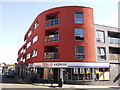
Tesco Express, Upper Sydenham
Mini supermarket as part of a modern development on the junction of Kirkdale (in front) and Willow Way (on the left).
Image: © David Anstiss
Taken: 2 Oct 2011
0.05 miles
6
The Windmill, Public House, Upper Sydenham
On the A2216 Kirkdale.
Image: © David Anstiss
Taken: 2 Oct 2011
0.05 miles
7
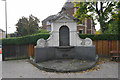
Diamond Jubilee fountain in Sydenham
To commemorate the Diamond Jubilee of Queen Victoria. It is not functioning now and is unlikely to be in future.
Image: © Bill Boaden
Taken: 10 Oct 2015
0.06 miles
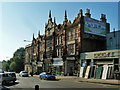
8
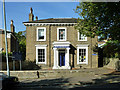
Grove Centre House
Part of the Grove Centre Church site. The actual Baptist/United Reformed church, rather less characterful than this building, is off shot to the right.
Image: © Robin Webster
Taken: 1 Oct 2011
0.06 miles
9
Kirkdale, Upper Sydenham
The A2216. The 202 bus is heading for Blackheath, although heading SSE down Kirkdale might not strike you as the best direction, Blackheath being northeast from here. Trust me, it'll get there, as long as it returns to the correct side of the road. The junction just ahead on the left is with Jews Walk.
Image: © Derek Harper
Taken: 9 May 2013
0.06 miles
10
A Remnant of Old Sydenham
These weatherboarded cottages in Kirkdale, near the junction with Dartmouth Road are a rare survival. Photo taken about 1975 and scanned from old slide.
Image: © David Wright
Taken: Unknown
0.07 miles