IMAGES TAKEN NEAR TO
Bell Green Lane, LONDON, SE26 5TP
Introduction
This page details the photographs taken nearby to Bell Green Lane, SE26 5TP by members of the Geograph project.
The Geograph project started in 2005 with the aim of publishing, organising and preserving representative images for every square kilometre of Great Britain, Ireland and the Isle of Man.

There are currently over 7.5m images from over14,400 individuals and you can help contribute to the project by visiting https://www.geograph.org.uk
Image Map (Loading...)


Getting Data...Please wait
Leaflet Map data © OpenStreetMap
Images are licensed for reuse under creativecommons.org/licenses/by-sa/2.0
Notes
- Clicking on the map will re-center to the selected point.
- The higher the marker number, the further away the image location is from the centre of the postcode.
Image Listing (98 Images Found)
Images are licensed for reuse under creativecommons.org/licenses/by-sa/2.0
Image
Details
Distance
1
Old Bath House, Bell Green, Lower Sydenham
Image: © Christopher Hilton
Taken: 18 Dec 2011
0.02 miles
2
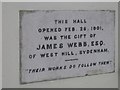
Old dedication stone, St Michael's House
St Michael's House is a modern block of social housing on the corner of Stanton Way but is on the site of the former Bell Green Mission Room and has retained this old dedication stone.
Image: © Stephen Craven
Taken: 13 Aug 2005
0.04 miles
3
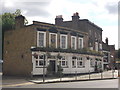
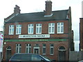
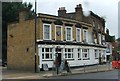
The Bell, Public house, Bell Green
Public house on the junction of Southend Lane (heading left) and Bell Green (road - on the right).
Partially marooned on a large traffic island within dual carriageways.
Image: © David Anstiss
Taken: 18 Sep 2011
0.06 miles
5
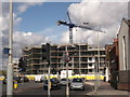
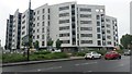
Construction site on Bell Green
Wilmott Dixon are building a large housing block on the junction of Bell Green (on the left) and Southend Lane.
This scheme is part of a multi-phase redevelopment programme on the former Bell Green gas works site that will create new homes, businesses and employment within Lewisham.The design and build project, will provide accommodation for 156 new apartments and commercial space. The housing will be completed in July 2012 and includes 85 homes for social rent and 71 for shared ownership.
See http://www.willmottdixongroup.co.uk/news?actv_news_news_id=38 for more details.
Image: © David Anstiss
Taken: 18 Sep 2011
0.08 miles
6
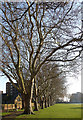
Planes, Home Park (2)
An otherwise modest little park includes a majestic avenue of plane trees. This conundrum is solved by Lewisham Council's website which explains that the park was formed from the former grounds of a big house, Home Park Lodge.
View from the other end: Image
Image: © Stephen Richards
Taken: 11 Feb 2012
0.09 miles
7
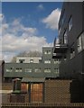
Flats at Bell Green
Flats at the east end of Holmshaw Close. This recent development is described in a planning application at http://councilmeetings.lewisham.gov.uk/Data/Planning%20Committee%20C/20091112/Agenda/25b2daa436fb4402b6b5ec9b229cbe575084BellGreen12November2009.PDF , for instance: "The southwest rear ground floor elevation facing the private gardens will be dark grey / charcoal aluminium", although some details have been amended.
Image: © Derek Harper
Taken: 9 May 2013
0.09 miles
8

Apartments and Road Junction at Bell Green
New residential development on former industrial land.
Image: © Des Blenkinsopp
Taken: 9 Aug 2016
0.11 miles
9
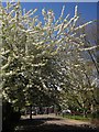
Blossom, Bell Green
Irresistible white cherry blossom on Holmshaw Close.
Image: © Derek Harper
Taken: 9 May 2013
0.11 miles