IMAGES TAKEN NEAR TO
Purbeck Gardens, LONDON, SE26 5FH
Introduction
This page details the photographs taken nearby to Purbeck Gardens, SE26 5FH by members of the Geograph project.
The Geograph project started in 2005 with the aim of publishing, organising and preserving representative images for every square kilometre of Great Britain, Ireland and the Isle of Man.

There are currently over 7.5m images from over14,400 individuals and you can help contribute to the project by visiting https://www.geograph.org.uk
Image Map
Images are licensed for reuse under creativecommons.org/licenses/by-sa/2.0
Notes
- Clicking on the map will re-center to the selected point.
- The higher the marker number, the further away the image location is from the centre of the postcode.
Image Listing (89 Images Found)
Images are licensed for reuse under creativecommons.org/licenses/by-sa/2.0
Image
Details
Distance
1
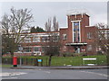
The former Dylon factory, Worsley Bridge Road, SE26
I am grateful to Pat Manning, who lived in the Sydenham area in the 1930s and 1940s for the following information about the building.
In the early 1930s, there were no factories on the land on the down side of the railway line between Hayes and London Bridge, but by about 1935, the Baird's television factory had been built, followed by three factories on the fields where previously donkeys would overwinter from the beaches at Southend. Maybreys was nearest the Pool River; then Gallenkamps; and then the chemists John Bell, Hills and Lucas which was taken over by the American firm Fassett & Johnson in the mid-1960s. The factory was later occupied by the Dylon textile company.
The factory has been demolished, and flats have been built on the site.
Back in 2007, developers drew up a scheme for "149 apartments of which 30% are affordable accommodation, there will also be 6,884 sq metres of business premises" http://www.ianritchiearchitects.co.uk/projects/dylon/ .
There was some local opposition https://sydenham.org.uk/forum/viewtopic.php?f=1&t=7980 and a public enquiry in 2010, but the council failed to reach a decision on the plans, and planning permission was granted on appeal in January 2015 - although, curiously, not for 149 apartments etc, but for "74 residential units; A1 retail; A3 café/restaurant; and a D1 crèche/nursery" https://www.richboroughestates.co.uk/appeals/dylon-international-ltd-worsley-bridge-road-bromley-se26-5hd/571.asp and https://www.richboroughestates.co.uk/live/appeals/571a.pdf .
The "development” that has now been built comprises "223 residential units and three commercial units" http://www.acorncommercial.co.uk/property-details/array-property-to-let-in-sydenham-london-london-21050/ and some residents have already moved in https://www.crestnicholson.com/developments/dylon-works/ .
The block is already on Streetview https://media.geograph.org.uk/files/496e05e1aea0a9c4655800e8a7b9ea28/Dylon_Streetview_2017_v2_2018_09_18.png .
Image: © Mike Quinn
Taken: 12 Mar 2010
0.02 miles
2

Closed Dylon factory
Looking along one wing towards the central block, with a similar wing beyond.
Image: © Robin Webster
Taken: 1 Oct 2011
0.02 miles
3
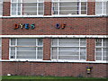
Remains of a sign on the former Dylon factory, Worsley Bridge Road, SE26
See Image
Image: © Mike Quinn
Taken: 12 Mar 2010
0.03 miles
4
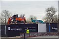
End of the Maybery Works
A small factory unit from before WW2 is now making way for housing.
Image: © Glyn Baker
Taken: 27 Mar 2019
0.03 miles
5

Tower on the former Dylon factory, Worsley Bridge Road, SE26
Image: © Mike Quinn
Taken: 9 Apr 2010
0.04 miles

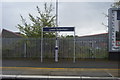
7

Path by the Pool River
This runs from Worsley Bridge Road to Meadowview Road. The river is on the right.
Image: © Robin Webster
Taken: 1 Oct 2011
0.06 miles
9
The Pool River north of Worsley Bridge Road, SE6
Image: © Mike Quinn
Taken: 9 Apr 2010
0.06 miles
10

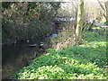
Pool River from Worsley Bridge
Looking upstream.
Image: © Robin Webster
Taken: 1 Oct 2011
0.06 miles