IMAGES TAKEN NEAR TO
Adamsrill Road, LONDON, SE26 4AY
Introduction
This page details the photographs taken nearby to Adamsrill Road, SE26 4AY by members of the Geograph project.
The Geograph project started in 2005 with the aim of publishing, organising and preserving representative images for every square kilometre of Great Britain, Ireland and the Isle of Man.

There are currently over 7.5m images from over14,400 individuals and you can help contribute to the project by visiting https://www.geograph.org.uk
Image Map
Images are licensed for reuse under creativecommons.org/licenses/by-sa/2.0
Notes
- Clicking on the map will re-center to the selected point.
- The higher the marker number, the further away the image location is from the centre of the postcode.
Image Listing (52 Images Found)
Images are licensed for reuse under creativecommons.org/licenses/by-sa/2.0
Image
Details
Distance
1
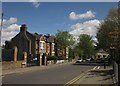
Adamsrill Road, SE26
On the left is the entrance to Adamsrill Primary School, opposite the junction with Champion Road.
Image: © Derek Harper
Taken: 9 May 2013
0.07 miles
4
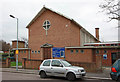
New Testament Church of God, Bell Green
This church is on the junction of Perry Rise (on the left) and the A212 Perry Hill (on the right).
Image: © David Anstiss
Taken: 18 Sep 2011
0.09 miles
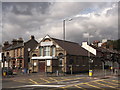
5
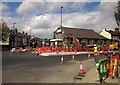
Junction at Bell Green
With extensive roadworks, part of the large-scale development of the area. To the right is the A212 to Catford; ahead is the B227 to Forest Hill. Between them on the corner is the New Testament Church of God, mapped as the Church of God of Prophecy, and also shown in Image "A classical building of 1883, {it} was originally Perry Hill Baptist Mission Hall; it became a Salvation Army hall in 1931" http://edithsstreets.blogspot.co.uk/2010_02_01_archive.html .
Image: © Derek Harper
Taken: 9 May 2013
0.09 miles
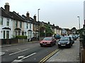
6
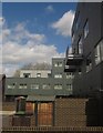
Flats at Bell Green
Flats at the east end of Holmshaw Close. This recent development is described in a planning application at http://councilmeetings.lewisham.gov.uk/Data/Planning%20Committee%20C/20091112/Agenda/25b2daa436fb4402b6b5ec9b229cbe575084BellGreen12November2009.PDF , for instance: "The southwest rear ground floor elevation facing the private gardens will be dark grey / charcoal aluminium", although some details have been amended.
Image: © Derek Harper
Taken: 9 May 2013
0.09 miles
7
St Michael & All Angels, Champion Crescent, Lower Sydenham - West end
Image: © John Salmon
Taken: 28 Jan 2011
0.11 miles
8
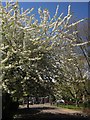
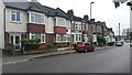
Blossom, Bell Green
Irresistible white cherry blossom on Holmshaw Close.
Image: © Derek Harper
Taken: 9 May 2013
0.12 miles
9
St Michael & All Angels, Champion Crescent, Lower Sydenham
Image: © John Salmon
Taken: 28 Jan 2011
0.12 miles
10
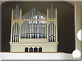
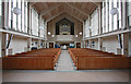
St Michael & All Angels, Lower Sydenham: organ
The church Image was rebuilt after the second world war, but the old pipe organ survived the bombing almost undamaged and is still in use on the north gallery of the present church.
Image: © Stephen Craven
Taken: 22 Jun 2015
0.12 miles