IMAGES TAKEN NEAR TO
Ross Road, LONDON, SE25 6TN
Introduction
This page details the photographs taken nearby to Ross Road, SE25 6TN by members of the Geograph project.
The Geograph project started in 2005 with the aim of publishing, organising and preserving representative images for every square kilometre of Great Britain, Ireland and the Isle of Man.

There are currently over 7.5m images from over14,400 individuals and you can help contribute to the project by visiting https://www.geograph.org.uk
Image Map
Images are licensed for reuse under creativecommons.org/licenses/by-sa/2.0
Notes
- Clicking on the map will re-center to the selected point.
- The higher the marker number, the further away the image location is from the centre of the postcode.
Image Listing (60 Images Found)
Images are licensed for reuse under creativecommons.org/licenses/by-sa/2.0
Image
Details
Distance
1
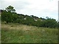
Whitehorse Meadow, South Norwood
Whitehorse Meadow comprises former allotments which were saved from redevelopment and dedicated as a public open space in the mid-1990s.
Image: © Christopher Hilton
Taken: 18 Sep 2012
0.05 miles
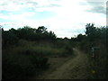
2
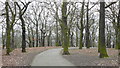
Woods in Grangewood Park
This view is looking towards the south west.
Image: © Peter Trimming
Taken: 28 Feb 2009
0.05 miles
3
Grangewood Park, South Norwood
Grangewood was originally part of the Manor of Whitehorse and the wood known as Whitehorse Wood was part of the Great North Wood. In 1800 the wood was completely surrounded by fields but by the mid 19th century the east and west sides of Whitehorse Wood were cleared for development, whilst the remaining 30 acres to the east of Grange Road were developed as a private estate. This now forms Grangewood Park. It had a mansion at the centre with extensive gardens to the south. Croydon Corporation bought Grangewood Park in 1900. The mansion and grounds were badly damaged in the Second World War and the house was demolished in 1960. The formal garden at the centre of the park marks the site. When the Council acquired the park they built a bandstand but this was also demolished after the Second World War.
Image: © Marathon
Taken: 21 Oct 2011
0.07 miles
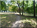
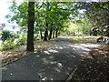
4
Grangewood Park
View of the park from just inside the southern gate.
Image: © Peter Trimming
Taken: 28 Feb 2009
0.07 miles
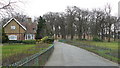
5
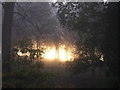
Grangewood Park from Grange Road, foggy morning
Image: © Christopher Hilton
Taken: 23 Nov 2011
0.07 miles
6
Whitehorse Meadow, South Norwood
Whitehorse Meadow comprises former allotments which were saved from redevelopment and dedicated as a public open space in the mid-1990s. This photograph is taken looking into the meadow from the Parry Road entrance.
Image: © Christopher Hilton
Taken: 18 Sep 2012
0.09 miles
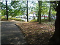
7
Grangewood Park alongside Ross Road
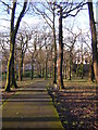
Grangewood was originally part of the Manor of Whitehorse and the wood known as Whitehorse Wood was part of the Great North Wood. In 1800 the wood was completely surrounded by fields but by the mid 19th century the east and west sides of Whitehorse Wood were cleared for development, whilst the remaining 30 acres to the east of Grange Road were developed as a private estate. This now forms Grangewood Park. It had a mansion at the centre with extensive gardens to the south. Croydon Corporation bought Grangewood Park in 1900. The mansion and grounds were badly damaged in the Second World War and the house was demolished in 1960. The formal garden at the centre of the park marks the site. When the Council acquired the park they built a bandstand but this was also demolished after the Second World War. Much of the park is what is called woodland park which is not as dense as ordinary woodland. The path leads down to Ross Road which is on the left here.
Image: © Marathon
Taken: 21 Oct 2011
0.09 miles
8
An entrance to Grangewood Park
Grangewood was originally part of the Manor of Whitehorse and the wood known as Whitehorse Wood was part of the Great North Wood. In 1800 the wood was completely surrounded by fields but by the mid 19th century the east and west sides of Whitehorse Wood were cleared for development, whilst the remaining 30 acres to the east of Grange Road were developed as a private estate. This now forms Grangewood Park. It had a mansion at the centre with extensive gardens to the south. Croydon Corporation bought Grangewood Park in 1900. The mansion and grounds were badly damaged in the Second World War and the house was demolished in 1960. The formal garden at the centre of the park marks the site. When the Council acquired the park they built a bandstand but this was also demolished after the Second World War. Much of the park is what is called woodland park which is not as dense as ordinary woodland. The path leads down to Ross Road.
Image: © Marathon
Taken: 21 Oct 2011
0.09 miles
9
Grangewood Park
The southern end, where the park falls steeply from the Norwood heights to central Thornton Heath.
Image: © Christopher Hilton
Taken: 7 Feb 2013
0.09 miles
10
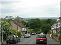
Parry Road, South Norwood: view towards Croydon
In the distance to the left, the commercial buildings of central Croydon. In the middle distance at the end of the road is Whitehorse Meadow Image, the surprisingly large open space that is tucked between houses here.
Image: © Christopher Hilton
Taken: 26 Jun 2012
0.09 miles