IMAGES TAKEN NEAR TO
Suffolk Road, LONDON, SE25 6EG
Introduction
This page details the photographs taken nearby to Suffolk Road, SE25 6EG by members of the Geograph project.
The Geograph project started in 2005 with the aim of publishing, organising and preserving representative images for every square kilometre of Great Britain, Ireland and the Isle of Man.

There are currently over 7.5m images from over14,400 individuals and you can help contribute to the project by visiting https://www.geograph.org.uk
Image Map
Images are licensed for reuse under creativecommons.org/licenses/by-sa/2.0
Notes
- Clicking on the map will re-center to the selected point.
- The higher the marker number, the further away the image location is from the centre of the postcode.
Image Listing (205 Images Found)
Images are licensed for reuse under creativecommons.org/licenses/by-sa/2.0
Image
Details
Distance
1
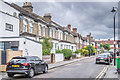
St Dunstan's Road
Cul de sac off High Street and Portland Road, licensed in 1870. The road is marked on the 1871 6" map with some housing, then named St John's Road. Full development, including the terrace nearest on the left, is shown on the 1895 1:1056 plan. The current name doesn't appear until the 1947 25" map.
Image: © Ian Capper
Taken: 6 Jul 2024
0.02 miles
3
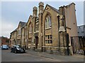
Stanley Technical High School & Halls, South Norwood
William Ford Robertson Stanley (1829-1909), inventor, collector, manufacturer scientific instruments and philanthropist, lived in Croydon, and founded and designed the halls and technical school known as Stanley Halls, at 12 South Norwood Hill. This Grade 2 listed building is sometimes described as the 'Jewel in South Norwood's Crown' - even if it is nowadays a little tarnished. From September 2007, Stanley Technical High will be known as Harris Academy at Stanley.
Image: © Philip Talmage
Taken: 17 Aug 2005
0.03 miles
4
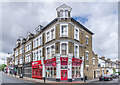
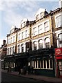
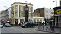
7 - 10 High Street
Building on the corner of High Street and St Dunstan's Road. Nos 7 - 8, towards the left, houses the Shelverdine Goathouse pub, formerly a Wetherspoon's pub named The William Stanley.
Image: © Ian Capper
Taken: 6 Jul 2024
0.05 miles
5
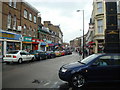
High Street, South Norwood, London SE25
Image: © Stacey Harris
Taken: 8 Nov 2008
0.05 miles
8
The William Stanley public house, South Norwood
Wetherspoon run pub on the A213 Norwood High Street.
Image: © David Anstiss
Taken: 18 Dec 2011
0.06 miles
9
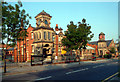
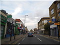
South Norwood
Junction of High Street and Station Road. Clock tower and the Alliance PH are visible in the centre of picture.
Image: © Peter Trimming
Taken: 28 Feb 2009
0.06 miles
10
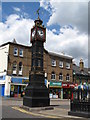
South Norwood Clock Tower (2)
It's had a makeover some time in the past couple of years - see Image
Image: © Mike Quinn
Taken: 4 Jul 2008
0.07 miles