IMAGES TAKEN NEAR TO
South Norwood Hill, LONDON, SE25 6AU
Introduction
This page details the photographs taken nearby to South Norwood Hill, SE25 6AU by members of the Geograph project.
The Geograph project started in 2005 with the aim of publishing, organising and preserving representative images for every square kilometre of Great Britain, Ireland and the Isle of Man.

There are currently over 7.5m images from over14,400 individuals and you can help contribute to the project by visiting https://www.geograph.org.uk
Image Map
Images are licensed for reuse under creativecommons.org/licenses/by-sa/2.0
Notes
- Clicking on the map will re-center to the selected point.
- The higher the marker number, the further away the image location is from the centre of the postcode.
Image Listing (37 Images Found)
Images are licensed for reuse under creativecommons.org/licenses/by-sa/2.0
Image
Details
Distance
1
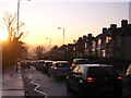
Sunrise, South Norwood Hill
On a winter morning the sun is only just above the horizon and the morning commute is in full swing.
Image: © Christopher Hilton
Taken: 2 Dec 2011
0.04 miles
2
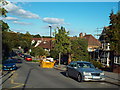
Cypress Road, South Norwood
This image was taken on a late September afternoon. The shadows were already quite long.
Image: © Malc McDonald
Taken: 27 Sep 2015
0.10 miles
3
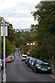
Cypress Road
Looking down Cypress Road from its junction with the main road (South Norwood Hill). Beyond the trees, the large buildings of the Sylvan Road Estate.
Image: © Christopher Hilton
Taken: 5 Sep 2011
0.12 miles
4
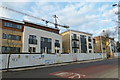
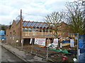
South Norwood Hill, Croydon
New flats under construction on S Norwood Hill.
Image: © Robert Rimell
Taken: 3 Jan 2011
0.12 miles
5
Cypress Road, Croydon
New construction work at Cypress Infants School.
Image: © Robert Rimell
Taken: 3 Jan 2011
0.13 miles
6
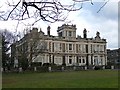
Former Falkland Park, South Norwood Hill
A substantial Italianate house in its own grounds, built c1890. Information from the Norwood Society.
Since 1923 it has been the home of Spurgeon's College, a Baptist training college founded by Charles Haddon Spurgeon.
The college kindly gave me permission to photograph.
Image: © Stephen Richards
Taken: Unknown
0.13 miles
7
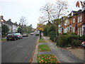
Howden Road, SE19
Unusually for a suburban road, the house-numbering on Howden Road goes not from one side to the other, but all the way up one side and down the other. The Victorian villas on the right, northern side are numbered consecutively uphill from 1 to 13; the numbering then returns down the other side, covering houses that are exclusively interwar semis. It seems clear that when the road was first laid out in the nineteenth century there were only houses on one side and for a couple of generations their inhabitants would have enjoyed a view onto fields, a view taken away when the land was broken into building plots between the wars.
Image: © Christopher Hilton
Taken: 17 Nov 2011
0.15 miles
8
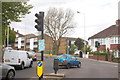
House Music event advertisement, Upper Norwood
Posters for this type of House music event regularly appear on traffic lights and lamp-posts along this road (similar versions are flyposted onto walls in the more urban centres); it is purely random chance that preserves this particular event for posterity.
Image: © Christopher Hilton
Taken: 10 May 2013
0.16 miles
10
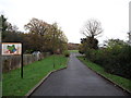
Entrance to South Norwood Lake and recreational grounds
Leading from Auckland Road.
Leads towards a sports pavilion and large playing fields.
Also a path leads through the woodland on the hills above the fields towards the Lake.
Image: © David Anstiss
Taken: 18 Dec 2011
0.19 miles