IMAGES TAKEN NEAR TO
Enmore Road, LONDON, SE25 5NH
Introduction
This page details the photographs taken nearby to Enmore Road, SE25 5NH by members of the Geograph project.
The Geograph project started in 2005 with the aim of publishing, organising and preserving representative images for every square kilometre of Great Britain, Ireland and the Isle of Man.

There are currently over 7.5m images from over14,400 individuals and you can help contribute to the project by visiting https://www.geograph.org.uk
Image Map
Images are licensed for reuse under creativecommons.org/licenses/by-sa/2.0
Notes
- Clicking on the map will re-center to the selected point.
- The higher the marker number, the further away the image location is from the centre of the postcode.
Image Listing (60 Images Found)
Images are licensed for reuse under creativecommons.org/licenses/by-sa/2.0
Image
Details
Distance
2
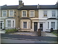
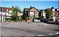
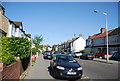
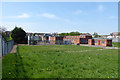
Victorian terraced houses on Birchanger Road, South Norwood
Row of Victorian terraced houses.
Image: © Merv Payne
Taken: 2 Jun 2006
0.08 miles
3
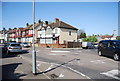
Mini roundabout, Birchanger Rd and Holland Rd
Image: © N Chadwick
Taken: 9 Apr 2011
0.09 miles
4
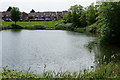
Brickfields Meadow
Brickfields Meadow is the site of the defunct Woodside brickworks of which Croydon Council was able to take control, as a planning gain, in the early 1990s.
The meadow covers an area of about 4.37 hectares. The meadow includes: large pond where fishing is allowed, dipping platform, Buddleia Valley, grassland and woodland planting, small woodland area, and a children's play area which includes a mini maze and roundabout.
Image: © Peter Trimming
Taken: 17 May 2020
0.10 miles
6
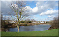
Brickfields Meadow Lake
A flooded clay pit on the site of a former brickworks. The area has been restored and is now a park, with only a series of hills and hollows remaining from its industrial past.
Image: © Des Blenkinsopp
Taken: 11 Feb 2020
0.11 miles
7
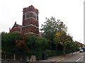
South Woodside United Reformed Church, Woodside (2)
Large church on the junction of Enmore road (on the left) and Cobden Road (on the right).
Image: © David Anstiss
Taken: 16 Oct 2011
0.11 miles
8
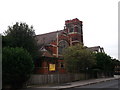
South Woodside United Reformed Church, Woodside
Large church on the junction of Enmore road (in front) and Cobden Road (behind the church).
Image: © David Anstiss
Taken: 16 Oct 2011
0.12 miles
10
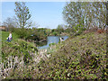
Lake in Brickfields Meadow
A recreation area on an old brickworks site. The lake was a clay pit.
Image: © Robin Webster
Taken: 19 Apr 2019
0.12 miles