IMAGES TAKEN NEAR TO
Spring Lane, LONDON, SE25 4SU
Introduction
This page details the photographs taken nearby to Spring Lane, SE25 4SU by members of the Geograph project.
The Geograph project started in 2005 with the aim of publishing, organising and preserving representative images for every square kilometre of Great Britain, Ireland and the Isle of Man.

There are currently over 7.5m images from over14,400 individuals and you can help contribute to the project by visiting https://www.geograph.org.uk
Image Map
Images are licensed for reuse under creativecommons.org/licenses/by-sa/2.0
Notes
- Clicking on the map will re-center to the selected point.
- The higher the marker number, the further away the image location is from the centre of the postcode.
Image Listing (47 Images Found)
Images are licensed for reuse under creativecommons.org/licenses/by-sa/2.0
Image
Details
Distance
1

Woodside station, 2005
View NE, towards Elmers End and London: ex-SE&CR Charing Cross/Cannon Street - Addiscombe until 6/97, also until 1983 to Sanderstead; reopened 5/00 on the Croydon Tramlink line to Elmers End and Beckenham Junction (for details, see Image).
Image: © Ben Brooksbank
Taken: 25 Sep 2005
0.02 miles
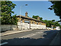
2
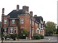
Woodside Fire Station
On the A222 Long Lane.
Image: © David Anstiss
Taken: 16 Oct 2011
0.06 miles
3
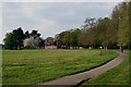
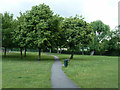
Ashburton Park
View from the eastern edge of the park.
Image: © Peter Trimming
Taken: 11 Apr 2020
0.06 miles
4
Academy Shirley Park Primary
An extraordinary order of words on the school sign. Is this in deference to some non-English languages?
Image: © Robin Webster
Taken: 11 Jun 2011
0.07 miles
6
In Ashburton Park
The path from the Spring Lane entrance.
Image: © Robin Webster
Taken: 11 Jun 2011
0.08 miles
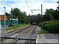
7
Woodside station: remains of
The railway which formerly ran beneath the bridge here has been converted into a tram line, but these disused roadside buildings remain from the railway era
Image: © Dr Neil Clifton
Taken: 28 May 2012
0.08 miles
8
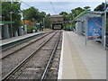
The old Woodside station from Woodside Tramlink stop
The railway line from Beckenham via Woodside to Addiscombe Road Croydon was opened on 1st April 1864. In 1885, a line opened from Woodside to South Croydon and after that Addiscombe (as it eventually became after 1955) was on the end of a branch from Woodside. The Woodside & South Croydon Line was closed in 1983, but the line from Elmers End via Woodside to Addiscombe remained open, although there was little demand with some off peak trains running empty. By 1993, Woodside station had become unstaffed and Addiscombe booking office was only open during the morning peak hours. Following the announcement that the line from Elmers End to Woodside was to be incorporated into the Croydon Tramlink scheme, it was clear that the line from Woodside to Addiscombe would close. The last day of service was Saturday 31st May 1997 and the Tramlink service through Woodside and on to Croydon began in 2000. The Tramlink stop is just south of the old station and the photograph is taken from the end of the platform looking across the foot crossing. The roadside building of the old station, the back of which is seen here, still stands, although it is disused, boarded up and covered in graffiti. The stairway to the former up platform to the left is still in use to provide access to the tram station. The stairway to the former down platform is fenced off. The rear wall of the up platform building has been kept as a retaining wall and as can be seen is now painted dark green.
Image: © Marathon
Taken: 25 Jul 2011
0.09 miles
9
Woodside railway station (site) / Tramlink stop, Greater London
Opened in 1871 by the South Eastern Railway on its line from Elmers End to Addiscombe, this station closed in 1997. A tramlink stop opened on the same site in 2000.
View north east towards Arena tramlink stop and Elmers End. The old station building was still extant on the bridge when this image was taken.
Image: © Nigel Thompson
Taken: 10 Aug 2010
0.09 miles
10
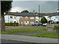
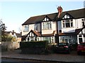
Small close off Longhurst Road
A curious angular terrace of houses with the end houses facing each other across the small roundabout. The arrangement is symmetrical about the angle behind the tree. There must be some very oddly shaped rooms.
Image: © Robin Webster
Taken: 11 Jun 2011
0.09 miles