IMAGES TAKEN NEAR TO
Malden Avenue, LONDON, SE25 4HR
Introduction
This page details the photographs taken nearby to Malden Avenue, SE25 4HR by members of the Geograph project.
The Geograph project started in 2005 with the aim of publishing, organising and preserving representative images for every square kilometre of Great Britain, Ireland and the Isle of Man.

There are currently over 7.5m images from over14,400 individuals and you can help contribute to the project by visiting https://www.geograph.org.uk
Image Map
Images are licensed for reuse under creativecommons.org/licenses/by-sa/2.0
Notes
- Clicking on the map will re-center to the selected point.
- The higher the marker number, the further away the image location is from the centre of the postcode.
Image Listing (52 Images Found)
Images are licensed for reuse under creativecommons.org/licenses/by-sa/2.0
Image
Details
Distance
1
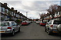
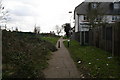
Southeast London: Malden Avenue
Looking south west from the Love Lane footpath
Image: © Dr Neil Clifton
Taken: 11 Mar 2011
0.03 miles
2
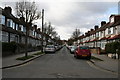
Southeast London: Chartham Road
Looking south west from the Love Lane footpath.
Image: © Dr Neil Clifton
Taken: 11 Mar 2011
0.03 miles
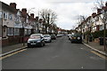
3
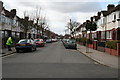
Southeast London: Waverley Road
Looking south west from Love Lane
Image: © Dr Neil Clifton
Taken: 11 Mar 2011
0.05 miles
4
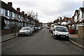
Southeast London: Hambrook Road
Looking north west from the Love Lane footpath
Image: © Dr Neil Clifton
Taken: 11 Mar 2011
0.08 miles
5
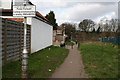
Southeast London: Love Lane footpath
Looking south east. This footpath runs south east from the southern end of the under-railway passage from Cambridge Road Image It connects to the rest of Love Lane, which is actually a road, leading to the Harrington Road tram stop.
Image: © Dr Neil Clifton
Taken: 11 Mar 2011
0.08 miles
6
Southeast London: Love Lane footpath
This looks northwest along the footpath, towards the subway under the railway which leads to Cambridge Road
Image: © Dr Neil Clifton
Taken: 11 Mar 2011
0.08 miles
7
Southeast London: Brooklyn Road
Looking south west from Love Lane
Image: © Dr Neil Clifton
Taken: 11 Mar 2011
0.08 miles
8
Path across end of Hambrook Road
Running parallel with the railway on the left.
Image: © Robin Webster
Taken: 11 Jun 2011
0.09 miles
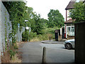
9
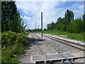
View from Harrington Road Tramlink stop
Opened in 2000 on the western edge of South Norwood Country Park, Harrington Road stop serves Harrington Road and surrounding roads to the west whilst on the east it is next to an entrance to Beckenham Cemetery. Just up the hill here is a sharp curve to the right after which Tramlink runs next to the railway line through Birkbeck to Beckenham Junction.
Image: © Marathon
Taken: 25 Jul 2011
0.12 miles
10
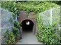
Foot tunnel under railway
From Hambrook Road and others this side, to Cambridge Road on the far side.
Image: © Robin Webster
Taken: 11 Jun 2011
0.12 miles