IMAGES TAKEN NEAR TO
James Joyce Walk, LONDON, SE24 0QT
Introduction
This page details the photographs taken nearby to James Joyce Walk, SE24 0QT by members of the Geograph project.
The Geograph project started in 2005 with the aim of publishing, organising and preserving representative images for every square kilometre of Great Britain, Ireland and the Isle of Man.

There are currently over 7.5m images from over14,400 individuals and you can help contribute to the project by visiting https://www.geograph.org.uk
Image Map
Images are licensed for reuse under creativecommons.org/licenses/by-sa/2.0
Notes
- Clicking on the map will re-center to the selected point.
- The higher the marker number, the further away the image location is from the centre of the postcode.
Image Listing (28 Images Found)
Images are licensed for reuse under creativecommons.org/licenses/by-sa/2.0
Image
Details
Distance
1
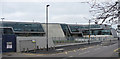
Evelyn Grace Academy, Shakespeare Road
A swanky addition to the area, and the first English project of the eminent architect Zaha Hadid, in 2006-10.
Academies are a hybrid - state-maintained but funded largely by other sources - and controversial because of those other funding sources and because they are outside local authority control.
Update: in October 2011 this building won the most prestigious architectural award, the Royal Institute of British Architects' Stirling Prize.
From the air: Image
Image: © Stephen Richards
Taken: 6 Mar 2011
0.04 miles
2
Depot, Shakespeare Road
A Lambeth Council vehicle depot I believe.
Its swankier neighbour is the Evelyn Grade Academy (see here: Image]).
Image: © Stephen Richards
Taken: 6 Mar 2011
0.05 miles
3
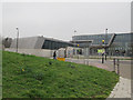
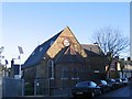
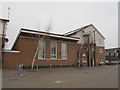
Evelyn Grace Academy, Loughborough Park (1)
This academy building opened in 2010. The school is part of the ARK network of academy schools. The main building is about 125m long so it took two photos to cover it. See Image and also Image for a view from the other side.
Image: © Stephen Craven
Taken: 19 Mar 2015
0.06 miles
4
Evelyn Grace Academy, Loughborough Park (2)
This academy building opened in 2010. The school is part of the ARK network of academy schools. The main building is about 125m long so it took two photos to cover it. See Image and also Image for a view from the other side.
Image: © Stephen Craven
Taken: 19 Mar 2015
0.07 miles
5
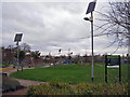
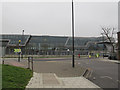
Milkwood Community Park
Viewed from an entrance from Heron Road. The facilities and features of the park include: children's playground, 5-a-side football pitch, basketball court, quiet area, trim trail, wildlife areas, and amphitheatre. Since 2003, over £500,000 has been invested to date to enable the park to offer local people of all ages and interests with a wide range of facilities for play, sport and social relaxation. In 2006 the park became Lambeth's first Green Flag Award site.
Image: © Richard Dorrell
Taken: 25 Dec 2011
0.12 miles
6
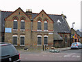
St John's Hall, Heron Road
Located on the junction of Heron Road (on the right) and Lowden Road. The building is a late Victorian hall (built about 1880) of traditional brick construction under a pitched slate roof. Although never consecrated, the building was used for worship until 1981, and was originally known as Camberwell St John's Mission. It was able to seat 300 people. The hall was used as a Community Centre from 1990. More recently it has been occupied by a children's nursery. The hall is currently for sale, and is likely to be improved and converted for community use.
Image: © Richard Dorrell
Taken: 25 Dec 2011
0.14 miles
7
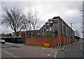
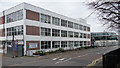
The Michael Tippett School, Lambeth
The Michael Tippett School was both the first Building Schools for the Future (BSF) school in London and the first Special Education Needs school to be built under the BSF programme. The school moved into this new building in Heron Road SE24 in February 2008. It provides 80 pupil places for students aged 11 to 18 who have profound and multiple special educational needs. The building was designed by London Eye architects, Marks Barfield, and built by Apollo Education.
The photo is taken from the junction between Heron Road (on the left) and Milkwood Road.
Image: © Richard Dorrell
Taken: 25 Dec 2011
0.14 miles
8
Former St John's church, Lowden Road
Built in 1880 as St John's Mission, Camberwell and later known as St John's church, Herne Hill. Now a nursery.
Image: © Stephen Craven
Taken: 21 Nov 2006
0.14 miles
9
Moorlands Community Centre, Brixton
The modern community centre occupies roughly the site of the long-vanished Sussex Road Mission Hall (part of the Anglican parish of St John, Angell Town). It was still in use as of 1961 according to a document on the Diocesan file, but demolished when the area was redeveloped in the 1970s.
Sussex Road was roughly on the alignment of the present Corry Drive Image, and existed, with terraced houses, by the time of the 1861 census, according to genealogy websites. It was part of the “Lambeth Wick” estate taken from Lord Holland’s estate.
Image: © Stephen Craven
Taken: 19 Mar 2015
0.15 miles
10
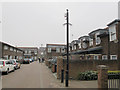
Corry Drive, Brixton (2)
The eastern arm of the road. See also Image
Corry Drive is roughly on the alignment of the former Sussex Road, part of the “Lambeth Wick” estate taken from Lord Holland’s estate in the mid 19th century. The area was completely redeveloped in the 1970s.
Image: © Stephen Craven
Taken: 19 Mar 2015
0.16 miles