IMAGES TAKEN NEAR TO
Fawnbrake Avenue, LONDON, SE24 0BE
Introduction
This page details the photographs taken nearby to Fawnbrake Avenue, SE24 0BE by members of the Geograph project.
The Geograph project started in 2005 with the aim of publishing, organising and preserving representative images for every square kilometre of Great Britain, Ireland and the Isle of Man.

There are currently over 7.5m images from over14,400 individuals and you can help contribute to the project by visiting https://www.geograph.org.uk
Image Map
Images are licensed for reuse under creativecommons.org/licenses/by-sa/2.0
Notes
- Clicking on the map will re-center to the selected point.
- The higher the marker number, the further away the image location is from the centre of the postcode.
Image Listing (81 Images Found)
Images are licensed for reuse under creativecommons.org/licenses/by-sa/2.0
Image
Details
Distance
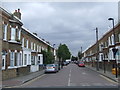
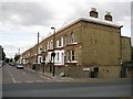
1
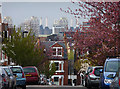
View from Kestrel Avenue
The facing house is on Fawnbrake Avenue. Beyond are the unmistakeable chimneys of Battersea Power Station (Image]). In front are three tower blocks just off Clapham Road near Stockwell.
Image: © Stephen Richards
Taken: 6 Apr 2012
0.12 miles
2
Milkwood Road, Herne Hill, from the train
Image: © Christopher Hilton
Taken: 7 Jun 2011
0.12 miles
3
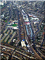
Brixton from the air
Looking straight up Shakespeare Road from a London City bound flight from Glasgow.
The distinctive shape of Zaha Hadid's Evelyn Grace Academy Image can be seen to the left of centre.
Image: © Thomas Nugent
Taken: 6 Feb 2012
0.12 miles
4
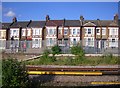
Milkwood Road
Row of terraced houses in Milkwood Road alongside railway line.
Image: © Alan Hughes
Taken: 11 Aug 2017
0.14 miles
5
Mayall Road, SE24
Mayall Road is a residential street near Brixton in South London. In 1981, this street was the scene of rioting in one of the worst outbreaks of civil disorder this country has experienced.
Image: © Malc McDonald
Taken: 30 May 2011
0.16 miles
6
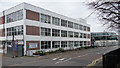
Depot, Shakespeare Road
A Lambeth Council vehicle depot I believe.
Its swankier neighbour is the Evelyn Grade Academy (see here: Image]).
Image: © Stephen Richards
Taken: 6 Mar 2011
0.17 miles
7
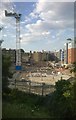
Building works on the Guinness Trust Estate, from the train
Image: © Christopher Hilton
Taken: 12 Jun 2014
0.17 miles
8
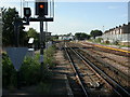
Herne Hill, railway junction
To the left, lines to Brixton and Victoria; to the right, to Loughborough Junction and Blackfriars.
Image: © Mike Faherty
Taken: 16 Aug 2009
0.17 miles
9
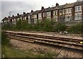
Herne Hill: Mayall Road, SE24
This is late Victorian terraced housing, typical of many such blocks in South London. The terrace is shown on the 1896 Ordnance Survey map but not on the edition of 1880, which gives a broad clue to the date that it was constructed. The street in front is Shakespeare Road.
Image: © Nigel Cox
Taken: 11 Sep 2009
0.18 miles
10
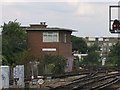
Herne Hill signalbox
Viewed from the platform of the adjacent station.
Image: © Stephen Craven
Taken: 19 Sep 2005
0.18 miles