IMAGES TAKEN NEAR TO
Ferndene Road, LONDON, SE24 0AA
Introduction
This page details the photographs taken nearby to Ferndene Road, SE24 0AA by members of the Geograph project.
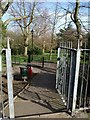
The Geograph project started in 2005 with the aim of publishing, organising and preserving representative images for every square kilometre of Great Britain, Ireland and the Isle of Man.

There are currently over 7.5m images from over14,400 individuals and you can help contribute to the project by visiting https://www.geograph.org.uk
Image Map
Images are licensed for reuse under creativecommons.org/licenses/by-sa/2.0
Notes
- Clicking on the map will re-center to the selected point.
- The higher the marker number, the further away the image location is from the centre of the postcode.
Image Listing (84 Images Found)
Images are licensed for reuse under creativecommons.org/licenses/by-sa/2.0
Image
Details
Distance
1
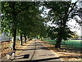
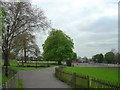
Path in Ruskin Park
One of the perimeter paths in the large park. This path is beside Ferndene Road.
Image: © David Anstiss
Taken: 2 Oct 2011
0.03 miles
2
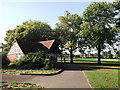
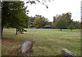
Toilet Block in Ruskin Park
Beside a perimeter path around the park. On the right are two large sports fields.
Image: © David Anstiss
Taken: 2 Oct 2011
0.04 miles
3
Denmark Hill: Ruskin Park, SE5
In Edwardian times local residents campaigned for a new public park in Denmark Hill, and the renowned parks designer J J Sexby laid out this site on 24 acres of ground. It was named Ruskin Park after John Ruskin, the famous artist, writer and social campaigner, who lived nearby from 1823 to 1871. The park was officially opened to the public in 1907, but was enlarged in 1910 by adding a further 12 acres of land to the south. This new site was separated from the original area of the park by a road called Dane Avenue that linked the present day Ferndene and Finsen Roads. It ran from the present day bend in Ferndene Road (behind the photographer in this view) to the north-eastern end of Finsen Road, and indeed the northern end of the current Ferndene Road, running up to Denmark Hill, formed part of Dane Avenue too. The 1938 Ordnance Survey map shows these arrangements but Dane Avenue now no longer exists.
In 2009 for the first time the park was awarded a Lambeth Council Green Flag Award.
Image: © Nigel Cox
Taken: 11 Sep 2009
0.06 miles
4
Entrance to Ruskin Park
An entrance from Ferndene Road near the eastern edge of the park.
Image: © Derek Harper
Taken: 11 Mar 2011
0.07 miles
5
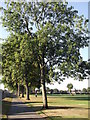
Path in Ruskin Park (2)
One of the perimeter paths in the large park. This path is beside Ferndene Road.
Image: © David Anstiss
Taken: 2 Oct 2011
0.08 miles
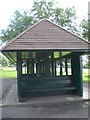
6
Ruskin Park, looking towards the shelter
Image: © john bristow
Taken: 12 Oct 2016
0.08 miles
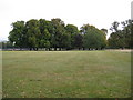
7
Ruskin Park, London
Ruskin Park, next to Denmark Hill, in southeast London.
Image: © Fan Yang
Taken: 16 Apr 2005
0.08 miles
8
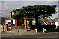
Denmark Hill
Seen at the junction with Acland Crescent. What an amazing tree in the front garden.
Image: © Peter Trimming
Taken: 2 Mar 2017
0.10 miles
9
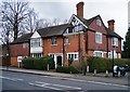
"Redholm", Champion Hill, Camberwell
"Redholm, the large house on Champion Hill behind the Fox on the Hill pub was built in 1885 to the design of the well known late Victorian/Edwardian architect John Belcher who lived in it until his death in 1913 ..." - quotation from this http://www.dulwichsociety.com/newsletters/40-winter-2006/263-john-belcher. Grade II listed, described at this http://www.dulwichsociety.com/newsletters/40-winter-2006/263-john-belcher.
Image: © Jim Osley
Taken: 22 Feb 2017
0.10 miles