IMAGES TAKEN NEAR TO
Taymount Rise, LONDON, SE23 3UN
Introduction
This page details the photographs taken nearby to Taymount Rise, SE23 3UN by members of the Geograph project.
The Geograph project started in 2005 with the aim of publishing, organising and preserving representative images for every square kilometre of Great Britain, Ireland and the Isle of Man.

There are currently over 7.5m images from over14,400 individuals and you can help contribute to the project by visiting https://www.geograph.org.uk
Image Map
Images are licensed for reuse under creativecommons.org/licenses/by-sa/2.0
Notes
- Clicking on the map will re-center to the selected point.
- The higher the marker number, the further away the image location is from the centre of the postcode.
Image Listing (122 Images Found)
Images are licensed for reuse under creativecommons.org/licenses/by-sa/2.0
Image
Details
Distance
1
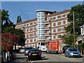
McLeod House, SE23
One of several similar blocks of flats here.
Image: © Robin Webster
Taken: 1 Oct 2011
0.09 miles
2

Converted church, Taymount Rise, SE23 (2)
See also Image
Image: © Mike Quinn
Taken: 4 Jul 2008
0.10 miles
3
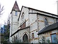
Converted church, Taymount Rise
Originally a Congregational church until 1939, thereafter a Spiritualist church until 1950, then Anglican as St Paul's. From the late 1980's a New Testament Assembly and finally sold in 1996 for conversion to residential use.
Image: © Stephen Craven
Taken: 11 Feb 2006
0.11 miles
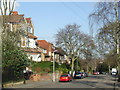
8
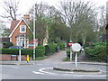
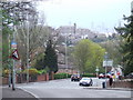
Roundabout, Sydenham Hill SE26
A small roundabout at the top of Sydenham Hill, SE26. The road drops down a steep gradient to the left. The narrow road straight ahead is Eliot Bank.
Image: © Malc McDonald
Taken: 3 Apr 2011
0.14 miles
9
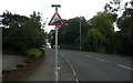
Sydenham Hill - Steep Hill 12%
Sydenham Hill, Forest Hill. 12% steep hill up sign.
Image: © Adam Morse
Taken: 8 Aug 2009
0.14 miles
10
Sydenham Hill, SE23
Sydenham Hill, with a warning sign indicating it is a 12% downhill gradient. 12% is 1-in-8. In the background is one of the blocks of flats at Dawson Heights, while in the distance, it is possible to make out some of the tall buildings in the City of London.
Image: © Malc McDonald
Taken: 3 Apr 2011
0.14 miles