IMAGES TAKEN NEAR TO
Sydenham Hill, LONDON, SE23 3PS
Introduction
This page details the photographs taken nearby to Sydenham Hill, SE23 3PS by members of the Geograph project.
The Geograph project started in 2005 with the aim of publishing, organising and preserving representative images for every square kilometre of Great Britain, Ireland and the Isle of Man.

There are currently over 7.5m images from over14,400 individuals and you can help contribute to the project by visiting https://www.geograph.org.uk
Image Map
Images are licensed for reuse under creativecommons.org/licenses/by-sa/2.0
Notes
- Clicking on the map will re-center to the selected point.
- The higher the marker number, the further away the image location is from the centre of the postcode.
Image Listing (194 Images Found)
Images are licensed for reuse under creativecommons.org/licenses/by-sa/2.0
Image
Details
Distance
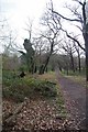
2
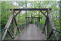
Cox's Walk
An Oak tree lined avenue cut in 1740.
Image: © N Chadwick
Taken: 9 May 2010
0.04 miles
3
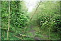
Dismantled railway, Sydenham Hill
The remains of the Nunhead to Crystal Palace (High Level) route. Opened to allow access to the Crystal Palace. The line closed to all traffic in 1954.
Image: © N Chadwick
Taken: 9 May 2010
0.04 miles
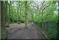
4
Entrance to Sydenham Hill Nature Reserve.
Image: © N Chadwick
Taken: 9 May 2010
0.05 miles
5

Trees by Cox's Walk
An Oak tree lined avenue cut in 1740.
Image: © N Chadwick
Taken: 9 May 2010
0.05 miles
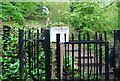
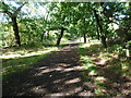
6
Sydenham Hill Wood
A London Wildlife Trust nature reserve http://www.wildlondon.org.uk/reserves/sydenham-hill-wood-and-coxs-walk see also Image
Image: © Glyn Baker
Taken: 8 Feb 2018
0.06 miles
7
Cox's Walk
This oak-lined formal avenue is known as Cox's Walk and leads from the junction of Dulwich Common and Lordship Lane into Sydenham Hill Woods. It was cut soon after 1732 by Francis Cox to connect his establishment of the Green Man Tavern and Dulwich Wells with the more popular Sydenham Wells. In 1739, Francis Cox sank a well for his own family. The water was found to be possessed of purgative qualities, and was for some time used medicinally. Whilst the water was popular much custom was drawn to the adjoining tavern, and its proprietor flourished. The Green Chain Walk now follows Cox's Walk between Sydenham Hill Woods and Dulwich Park.
Image: © Marathon
Taken: 21 Sep 2011
0.07 miles
8
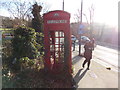
A K6 telephone box looking rather sorry for itself at the corner of London Road and Sydenham Hill #2
Overgrown with ivy and missing several of its glass panels is this red K6 telephone box at the junction of London Road and Sydenham Hill. Looking south.
Image: © Robert Lamb
Taken: 27 Jan 2013
0.08 miles
9
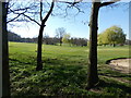
No golf today
All is peaceful on the Dulwich and Sydenham Golf Course, in the first week of lockdown.
Image: © Brian Whittle
Taken: 25 Mar 2020
0.08 miles
10
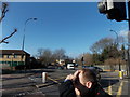
View up London Road from the Sydenham Hill junction
Looking north-northwest. The spire of St Peter's Ecumenical Centre can be seen above the trees in the centre of the image.
Image: © Robert Lamb
Taken: 27 Jan 2013
0.09 miles