IMAGES TAKEN NEAR TO
Wood Vale, LONDON, SE23 3DR
Introduction
This page details the photographs taken nearby to Wood Vale, SE23 3DR by members of the Geograph project.
The Geograph project started in 2005 with the aim of publishing, organising and preserving representative images for every square kilometre of Great Britain, Ireland and the Isle of Man.

There are currently over 7.5m images from over14,400 individuals and you can help contribute to the project by visiting https://www.geograph.org.uk
Image Map
Images are licensed for reuse under creativecommons.org/licenses/by-sa/2.0
Notes
- Clicking on the map will re-center to the selected point.
- The higher the marker number, the further away the image location is from the centre of the postcode.
Image Listing (193 Images Found)
Images are licensed for reuse under creativecommons.org/licenses/by-sa/2.0
Image
Details
Distance
2
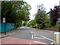
Dulwich: Underhill Road
All cabbies know that the quickest way to Peckham, avoiding the 'Grove Tavern' lights and the congestion around the 'Plough' is to drive down here to its junction with Barry Road.
Image: © Dr Neil Clifton
Taken: 18 Jul 2012
0.01 miles
5
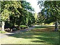
In Horniman Gardens
The path along the west side of the gardens.
Image: © Robin Webster
Taken: 1 Oct 2011
0.04 miles
6
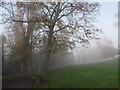
Path in Horniman Park
This path leads from the A206 London Road, through the park on a hill, towards Westwood Park.
The winter fog has not left the higher parts of London today!
Image: © David Anstiss
Taken: 20 Nov 2011
0.04 miles
7
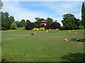
Dog exercise area, Horniman Gardens
Looking up towards the bandstand, on a hot Sunday afternoon in July. Here are two links, one for the Horniman Museum
http://www.horniman.ac.uk/
and one with more photos of the Gardens http://www.foresthill.org.uk/horniman_museum.html
Image: © Danny P Robinson
Taken: 16 Jul 2006
0.05 miles
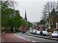
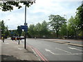
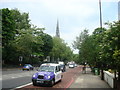
9
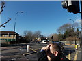
View up London Road from the Sydenham Hill junction
Looking north-northwest. The spire of St Peter's Ecumenical Centre can be seen above the trees in the centre of the image.
Image: © Robert Lamb
Taken: 27 Jan 2013
0.06 miles
10
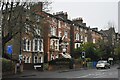
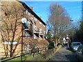
Houses on Lordship Lane
Most of these very large houses are subdivided into flats, of which the line of wheelie bins is a tell-tale sign.
Image: © David Martin
Taken: 27 Nov 2022
0.06 miles