IMAGES TAKEN NEAR TO
Waldram Park Road, LONDON, SE23 2PL
Introduction
This page details the photographs taken nearby to Waldram Park Road, SE23 2PL by members of the Geograph project.
The Geograph project started in 2005 with the aim of publishing, organising and preserving representative images for every square kilometre of Great Britain, Ireland and the Isle of Man.

There are currently over 7.5m images from over14,400 individuals and you can help contribute to the project by visiting https://www.geograph.org.uk
Image Map (98 Images)


Getting Data...Please wait
Leaflet Map data © OpenStreetMap
Images are licensed for reuse under creativecommons.org/licenses/by-sa/2.0
Notes
- Clicking on the map will re-center to the selected point.
- The higher the marker number, the further away the image location is from the centre of the postcode.
Image Listing (98 Images Found)
Images are licensed for reuse under creativecommons.org/licenses/by-sa/2.0
Image
Details
Distance
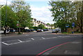
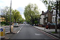
1
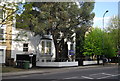
Bend on the South Circular Road, Forest Hill
This bend illustrates how there is no such actual road as the South Circular. Instead it connects adjacent A roads between Kew Bridge and Woolwich Ferry, and where there were none then widens local residential roads such as this one. In fact this is not a real bend on a road, but a junction where the existing roads were widened to fit in the new A road whenever it was built. Local interest groups have ensured the South Circular never becomes a dual carriageway or loses any of its traffic lights unlike the gradual (but far from total) transformation of its northern counterpart, which included an entirely new stretch at almost motorway speed along the river Roding through East Ham in the 1990s, where it had previously fizzled out into passing through town centres like these to the south.
Image: © David Howard
Taken: 16 Feb 2014
0.03 miles
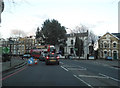
5
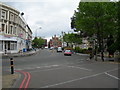
A205 South Circular Road at Forest Hill
This stretch is Sunderland Road, both where I am standing and the road beyond. Stanstead Road is ahead in the distance, running left to right past the Balm of Gilead Church Image Spot the white vans near the church, following the road round. It demonstrates very well the twisting, improvised nature of the South Circular, which has been cobbled together out of what were once suburban side streets.
Image: © Danny P Robinson
Taken: 12 May 2007
0.05 miles
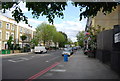
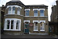
8
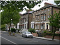
Houses on Waldram Park Road
These fine old houses will by now have been converted into flats. This is the A205 South Circular, a busy through route. On street parking is out of the question.
Image: © Danny P Robinson
Taken: 12 May 2007
0.05 miles