IMAGES TAKEN NEAR TO
Perry Vale, LONDON, SE23 2LQ
Introduction
This page details the photographs taken nearby to Perry Vale, SE23 2LQ by members of the Geograph project.
The Geograph project started in 2005 with the aim of publishing, organising and preserving representative images for every square kilometre of Great Britain, Ireland and the Isle of Man.

There are currently over 7.5m images from over14,400 individuals and you can help contribute to the project by visiting https://www.geograph.org.uk
Image Map
Images are licensed for reuse under creativecommons.org/licenses/by-sa/2.0
Notes
- Clicking on the map will re-center to the selected point.
- The higher the marker number, the further away the image location is from the centre of the postcode.
Image Listing (70 Images Found)
Images are licensed for reuse under creativecommons.org/licenses/by-sa/2.0
Image
Details
Distance
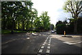
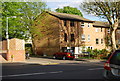
5
Inglemere Road / Bampton Road, SE23
Shows the location of Image
Image: © Mike Quinn
Taken: 4 Jul 2008
0.11 miles
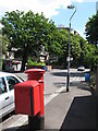
6
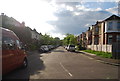
Bampton Road, Forest Hill
Bampton Road in Forest Hill, on a sunny day in early October. Leaves on the trees are starting to turn autumnal gold.
Image: © Malc McDonald
Taken: 4 Oct 2015
0.12 miles
7
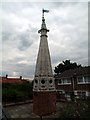
St Antholin's church spire, Sydenham SE26
St. Antholin’s, completed in 1688 and regarded as one of Wren’s finest City churches, stood on the corner of Sise Lane and Budge Row/Watling Street, roughly on the site now occupied by the Temple of Mithras, before the building of Queen Victoria Street. St. Antholin (a corruption of St. Anthony) was dedicated to St. Anthony of Egypt. The spire (one of Wren’s few true spires and the only stone one) was octagonal. St. Antholin’s was demolished in 1875. However, in 1829, the upper part of the spire had been replaced and the portion taken down sold for £5 to Robert Harrild, a printer, who had it erected on his property, Round Hill House in Sydenham. And here it stands, now surrounded by a cul-de-sac of modern town houses.
Image: © Philip Talmage
Taken: 21 Aug 2005
0.12 miles
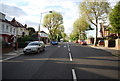
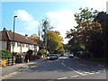
8
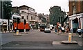
Forest Hill Summer 1989
Looking up the South Circular from the junction with Dartmouth Road.Day and Month uncertain.
Image: © David Wright
Taken: Unknown
0.12 miles
9
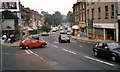
Forest Hill - Summer 1989
Looking along the South Circular to junction with Devonshire Road.Day and Month uncertain.
Image: © David Wright
Taken: Unknown
0.12 miles