IMAGES TAKEN NEAR TO
Velde Way, LONDON, SE22 8TP
Introduction
This page details the photographs taken nearby to Velde Way, SE22 8TP by members of the Geograph project.
The Geograph project started in 2005 with the aim of publishing, organising and preserving representative images for every square kilometre of Great Britain, Ireland and the Isle of Man.

There are currently over 7.5m images from over14,400 individuals and you can help contribute to the project by visiting https://www.geograph.org.uk
Image Map
Images are licensed for reuse under creativecommons.org/licenses/by-sa/2.0
Notes
- Clicking on the map will re-center to the selected point.
- The higher the marker number, the further away the image location is from the centre of the postcode.
Image Listing (45 Images Found)
Images are licensed for reuse under creativecommons.org/licenses/by-sa/2.0
Image
Details
Distance
1
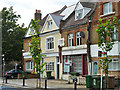
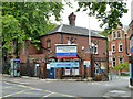
Former shops, East Dulwich Grove, SE22
Converted to housing, except one which seems to have closed down. Later views show this was converted too. The first floor stone has the date 1886.
Image: © Robin Webster
Taken: 23 Jul 2011
0.05 miles
2
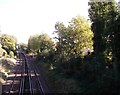
Railway to East Dulwich
As seen from Image
This line leads from Tulse Hill (via North Dulwich) towards East Dulwich and Peckham Rye.
Image: © David Anstiss
Taken: 2 Oct 2011
0.08 miles
3
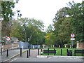
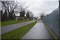
Greendale, SE22
Greendale, a shared walking and cycling path in East Dulwich. The bridge in the foreground takes the path over a railway line.
Image: © Malc McDonald
Taken: 17 Oct 2010
0.08 miles
5
Dulwich Hospital
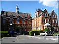
Dulwich Hospital in East Dulwich Grove was designed by Henry Jarvis and built on seven acres of land purchased by the Guardians of the Poor of the Parish of St Saviour, Southwark, for the price of £50,000 in 1885. At the time of opening in 1887, it had 723 beds. It was transformed from an infirmary into the Southwark Military Hospital during the First World War, when it is estimated 14,000–15,000 wounded soldiers were treated at the hospital. It has a beautifully kept war memorial in front of the hospital commemorating those soldiers who died here - see http://www.geograph.org.uk/photo/2605542. After the Poor Law was abolished in 1930, the Southwark Union Infirmary was renamed Dulwich Hospital.
Image: © Marathon
Taken: 14 Sep 2011
0.11 miles
6
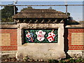
Crest on Greendale railway Bridge
One of the three decorated columns on the footbridge over the railway.
See Image
Image: © David Anstiss
Taken: 2 Oct 2011
0.11 miles
7
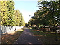
Greendale
This footpath and cyclepath leads from East Dulwich Road up towards Blanchedowne (road) near Denmark Hill .
Also used by National Cycle Route 23.
On the right is a sports pavilion of Dulwich High school.
Image: © David Anstiss
Taken: 2 Oct 2011
0.12 miles
10
Gate lodge, Dulwich Community Hospital
Dated 1886 on the stone on the end wall. This also has 'SSU', standing for St. Saviour's Union, the body which set up Dulwich Hospital here, of which the current hospital is but a surviving fragment.
Image: © Robin Webster
Taken: 23 Jul 2011
0.12 miles