1
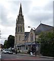
The Passmore Edwards Dulwich Public Library
On the junction of the A2216 Lordship lane (in front) and Eynella Lane (on the right).
See http://www.passmoreedwards.org.uk/pages/Libraries/Dulwich.htm for more information on this old library.
Image: © David Anstiss
Taken: 26 Nov 2010
0.01 miles
2
The Passmore Dulwich Library
On the junction of the A2216 Lordship lane (in front) and Eynella Lane (on the right).
See http://www.passmoreedwards.org.uk/pages/Libraries/Dulwich.htm for more information on this old library.
Image: © David Anstiss
Taken: 26 Nov 2010
0.01 miles
3
Emmanuel United Church, Barry Road
Image: © John Salmon
Taken: 15 Nov 2015
0.02 miles
4
Wall painting on house, Barry Road
Image: © John Salmon
Taken: 15 Nov 2015
0.02 miles
5
Dulwich: Two for the price of one
Just squeezing into this gridsquare at its extreme northeast corner, there are two churches in this photograph. The nearest one is shared by the United Reformed Church and the Methodists: The one further away, with the spire, used to be a church but is now in commercial use as Barry House.
Image: © Dr Neil Clifton
Taken: 18 Jul 2012
0.02 miles
6
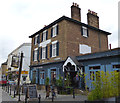
Dulwich: The 'Plough'
This just squeezes into the southeast corner of the gridsquare. While it is unremarkable in terms of outward appearance, it is an excellent pub, with a very wide range of beers, including about five real ales, available. There is also food, and the staff very friendly and helpful. There is a beer garden too.
Image: © Dr Neil Clifton
Taken: 18 Jul 2012
0.03 miles
7
The Plough, Lordship Lane, East Dulwich SE22
Photo taken c1990. Wikipedia http://en.wikipedia.org/wiki/East_Dulwich says "One area of East Dulwich is called Dulwich Plough. This was named after a pub, "The Plough" which had been there since 1830. The pub was taken over by Bass Taverns pub chain and changed its name in 1996 to the Goose and Granite. Despite the efforts of a "Save Dulwich Plough" campaign the new name was kept for almost ten years. The name reverted to The Plough in 2005."
Image: © David Wright
Taken: Unknown
0.03 miles
8
The Plough, East Dulwich
Image: © Robert Eva
Taken: 14 Jan 2019
0.03 miles
9
St. Thomas More Roman Catholic Church
On the A2216 Lordship Lane.
Image: © David Anstiss
Taken: 26 Nov 2010
0.03 miles
10
The Plough, East Dulwich
Image: © Chris Whippet
Taken: 23 Aug 2015
0.04 miles


