IMAGES TAKEN NEAR TO
Rosendale Road, LONDON, SE21 8EZ
Introduction
This page details the photographs taken nearby to Rosendale Road, SE21 8EZ by members of the Geograph project.
The Geograph project started in 2005 with the aim of publishing, organising and preserving representative images for every square kilometre of Great Britain, Ireland and the Isle of Man.

There are currently over 7.5m images from over14,400 individuals and you can help contribute to the project by visiting https://www.geograph.org.uk
Image Map
Images are licensed for reuse under creativecommons.org/licenses/by-sa/2.0
Notes
- Clicking on the map will re-center to the selected point.
- The higher the marker number, the further away the image location is from the centre of the postcode.
Image Listing (116 Images Found)
Images are licensed for reuse under creativecommons.org/licenses/by-sa/2.0
Image
Details
Distance
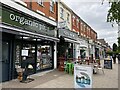
1
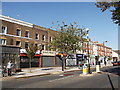
Row of Shops, Rosendale Road
This small parade of shops is between Idmiston Road and Eastmearn Road.
Has a widen section of pavement outside.
Image: © David Anstiss
Taken: 2 Oct 2011
0.03 miles
2
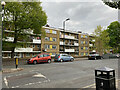
Flats, Rosendale Road, West Dulwich
Facing the row of shops in Image
Image: © Robin Stott
Taken: 29 Apr 2022
0.03 miles
4
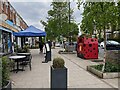
Landscaped shop frontages, Rosendale Road, West Dulwich, London
Businesses have tried to nurture a social space for the good life in West Dulwich, with partial separation from traffic. But some might say it's just cluttered.
Image: © Robin Stott
Taken: 29 Apr 2022
0.03 miles
5
Rosendale Road shops ? everything for life in West Dulwich
Image: © Robin Stott
Taken: 29 Apr 2022
0.03 miles
6
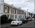
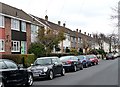
Houses, Idmiston Road
A modest but attractive terrace of houses dating probably from the second half of the C19th.
Image: © Stephen Richards
Taken: Unknown
0.04 miles
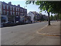
7
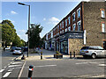
Parade of shops, Rosendale Road, West Dulwich, London
The shops reflect the tastes, needs and pockets of a well-heeled population. The view is from the corner of Eastmearn Road.
Image: © Robin Stott
Taken: 3 Sep 2021
0.04 miles
8
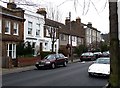
Houses, Chancellor Grove (2)
A group of houses of varying vintages and in a variety of styles. The group of three C20th houses still have their original metal Crittall windows.
Image: © Stephen Richards
Taken: Unknown
0.07 miles
9
Houses, Chancellor Grove (1)
A group of houses, uncommonly for this area dating probably from the 1960s or 1970s.
Image: © Stephen Richards
Taken: Unknown
0.08 miles
10

The Rosendale, Rosendale Road
At the corner of Park Hall Road. A mid-C19th pub, tarted up in recent years like so many others and now I suppose counts as a gastro-pub. Grade II listed.
Image: © Stephen Richards
Taken: 23 Dec 2012
0.08 miles