IMAGES TAKEN NEAR TO
Grange Lane, LONDON, SE21 7LH
Introduction
This page details the photographs taken nearby to Grange Lane, SE21 7LH by members of the Geograph project.
The Geograph project started in 2005 with the aim of publishing, organising and preserving representative images for every square kilometre of Great Britain, Ireland and the Isle of Man.

There are currently over 7.5m images from over14,400 individuals and you can help contribute to the project by visiting https://www.geograph.org.uk
Image Map
Images are licensed for reuse under creativecommons.org/licenses/by-sa/2.0
Notes
- Clicking on the map will re-center to the selected point.
- The higher the marker number, the further away the image location is from the centre of the postcode.
Image Listing (14 Images Found)
Images are licensed for reuse under creativecommons.org/licenses/by-sa/2.0
Image
Details
Distance
1
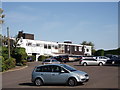
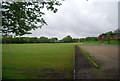
Dulwich and Sydenham Hill Golf Course Clubhouse
At the end of Grange Lane.
Image: © David Anstiss
Taken: 2 Oct 2011
0.00 miles
2
South London Scout Centre
At the end of Grange Lane. Near Dulwich Wood.
Image: © David Anstiss
Taken: 2 Oct 2011
0.04 miles
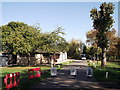
3
Grange Lane, off College Road
A road to the golf course and allotments but definitely not access to Sydenham Woods beyond.
Image: © Robert Eva
Taken: 24 Mar 2019
0.08 miles
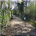
4
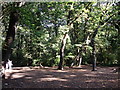
Track in Dulwich Wood
This track leads from Grange Lane towards Upper Sydenham.
It passes through the wood, managed by the Dulwich Estate.
Image: © David Anstiss
Taken: 2 Oct 2011
0.12 miles
5
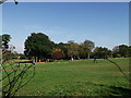
Dulwich and Sydenham Hill Golf Course
As seen from Grange Lane.
Image: © David Anstiss
Taken: 2 Oct 2011
0.12 miles
6

View towards London from Dulwich golf course
Image: © Christopher Hilton
Taken: 14 Sep 2008
0.16 miles
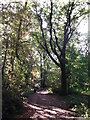
7
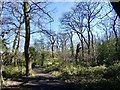
Track junction in Dulwich Wood
This path/track junction is on the track from Low Cross Wood Lane towards Grange Lane. Another track leads right into the wood.
Image: © David Anstiss
Taken: 2 Oct 2011
0.18 miles
10

Modern drain grid, Dulwich
I suspect (and hope) that I'm not alone in contributors to Geograph in reading drain grids: what they say often opens up layers of a place's administrative past. In this case, rather than the writing identifying a local ironworks or the administrative body that put it there, as one would expect from a nineteenth century grid, we have a standardised drain-grid supplied by a manufacturer interchangeably to any location, whose lettering includes (the first time I've seen this on a grid) a URL.
Image: © Christopher Hilton
Taken: 2 Jun 2013
0.22 miles