IMAGES TAKEN NEAR TO
Wickham Lane, LONDON, SE2 0XW
Introduction
This page details the photographs taken nearby to Wickham Lane, SE2 0XW by members of the Geograph project.
The Geograph project started in 2005 with the aim of publishing, organising and preserving representative images for every square kilometre of Great Britain, Ireland and the Isle of Man.

There are currently over 7.5m images from over14,400 individuals and you can help contribute to the project by visiting https://www.geograph.org.uk
Image Map
Images are licensed for reuse under creativecommons.org/licenses/by-sa/2.0
Notes
- Clicking on the map will re-center to the selected point.
- The higher the marker number, the further away the image location is from the centre of the postcode.
Image Listing (46 Images Found)
Images are licensed for reuse under creativecommons.org/licenses/by-sa/2.0
Image
Details
Distance
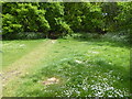
1
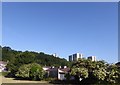
View from the Green Chain Walk near Wickham Lane
The Green Chain Walk here drops down from Bostall Woods to cross this patch of grassland in between houses before crossing Wickham Lane, houses of which can be seen on the far left. The Green Chain Walk then rises up steeply through the woods ahead to reach Plumstead Common. The flats on the right are around Grosmont Road.
Image: © Marathon
Taken: 25 May 2020
0.08 miles
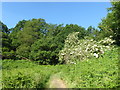
2
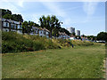
Open land alongside Wickham Lane
Part of the Green Chain Walk runs parallel to the road here.
Image: © Stephen Craven
Taken: 14 Jul 2013
0.09 miles
3
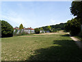
Open land between Wickham Lane and Bostall Woods
The path to the right of the photo is part of the Green Chain Walk.
Image: © Stephen Craven
Taken: 14 Jul 2013
0.10 miles
4
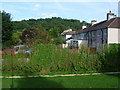
Back gardens of houses in Rutherglen Road
This view from Wickham Lane looks across the back gardens of houses in Rutherglen Road to Bostall Woods beyond.
Image: © Marathon
Taken: 30 Aug 2013
0.12 miles
5
The Green Chain Walk descends from Winns Common
These steep steps lead down through woodland from Winns Common which is part of Plumstead Common to Wickham Lane. Beyond Wickham Lane the Green Chain Walk leads up to Bostall Woods.
Image: © Marathon
Taken: 30 Apr 2020
0.13 miles
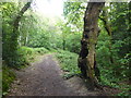
6
Path up on to Bleak Hill
These path leads on to steep steps up through the woodland ahead on the way from King's Highway to Winns Common, which in turn is part of Plumstead Common. It forms part of the Green Chain Walk.
Image: © Marathon
Taken: 25 May 2020
0.13 miles
7
The Green Chain Walk on the way to Bostall Woods
This path leads down through woodland from Winns Common which is part of Plumstead Common to Wickham Lane. Beyond Wickham Lane the Green Chain Walk leads up to Bostall Woods.
Image: © Marathon
Taken: 30 Apr 2020
0.13 miles
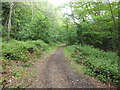
8
The Green Chain Walk enters Bostall Woods
The Green Chain Walk has descended from Winns Common which is part of Plumstead Common to Wickham Lane. Beyond Wickham Lane the Green Chain Walk leads up to Bostall Woods which it enters here.
Image: © Marathon
Taken: 30 Apr 2020
0.13 miles
9
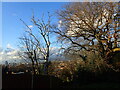
View at Plumstead Common
This view is at the top of Grosmont Road where it reaches Winn Common Road. The views across London are extensive.
Image: © Marathon
Taken: 5 Feb 2021
0.14 miles
10
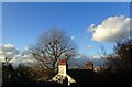
Chimney pots at Plumstead Common
This view is at the top of Grosmont Road where it reaches Winn Common Road. The views across London are extensive. The chimneys belong to a house at the top of Purrett Road.
Image: © Marathon
Taken: 5 Feb 2021
0.14 miles