IMAGES TAKEN NEAR TO
Crumpsall Street, LONDON, SE2 0LR
Introduction
This page details the photographs taken nearby to Crumpsall Street, SE2 0LR by members of the Geograph project.
The Geograph project started in 2005 with the aim of publishing, organising and preserving representative images for every square kilometre of Great Britain, Ireland and the Isle of Man.

There are currently over 7.5m images from over14,400 individuals and you can help contribute to the project by visiting https://www.geograph.org.uk
Image Map
Images are licensed for reuse under creativecommons.org/licenses/by-sa/2.0
Notes
- Clicking on the map will re-center to the selected point.
- The higher the marker number, the further away the image location is from the centre of the postcode.
Image Listing (91 Images Found)
Images are licensed for reuse under creativecommons.org/licenses/by-sa/2.0
Image
Details
Distance
2

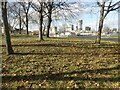
Knee Hill approaching the McLeod Road roundabout
Heading towards one of London's newest suburbs, Thamesmead, which added to the population enough to require a new postcode, London's last, SE28, which was divided from SE2. It was previously marshes along the river and holds the unique position of being the only point south of the Thames east of Charing Cross to also be north of Charing Cross at its highest point.
Image: © David Howard
Taken: 11 Mar 2012
0.08 miles
3
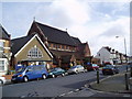
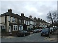
St. Michael and All Angels Church, Abbey Wood Road, London SE2
The local Church of England has a large and active congregation. There is also a Catholic church just around the corner.
Image: © Dr Neil Clifton
Taken: 30 Mar 2006
0.09 miles
4

Abbey Wood: The Harrow Inn
This public house is mentioned in a description of the hamlet of Abbey Wood in the late 1860s when it was one of the very few buildings. It is at the junction of Abbey Wood Road with Wilton Road. The A2041 Harrow Manorway flyover across the railway can be seen in the distance on the left. Various on-line pub guides describe the clientele of the pub as "local".
Update November 2011
Driving past the other day the photographer noted that the public house had been demolished, and checking out other websites it had seemingly already gone by December 2009. This is a shame really because the building, with its high windows up in the soffit supports, was quite unusual and a good example of an early Victorian public house. It does not appear to have been locally listed either.
There is a great photo of the last tram in Abbey Wood here http://www.flickr.com/photos/taffytank/4394748546/ with the Harrow Inn behind. Evidently the chimney on the far right of the tram photo had long since been demolished by 2007.
Image: © Nigel Cox
Taken: 26 Mar 2007
0.09 miles
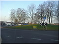
6
Roundabout at the foot of Knee Hill
This roundabout is at the foot of Knee Hill near Abbey Wood station and has a fine show of crocuses as seen on 25th February. The tower blocks of Thamesmead can be seen in the distance. A close up on the roundabout can be seen at https://www.geograph.org.uk/photo/7109845
Image: © Marathon
Taken: 25 Feb 2022
0.11 miles
7
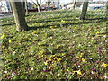
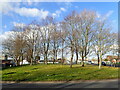
On the roundabout near Abbey Wood station
This roundabout is at the foot of Knee Hill near Abbey Wood station and has a fine show of crocuses as seen on 25th February.
Image: © Marathon
Taken: 25 Feb 2022
0.12 miles
8
Roundabout at the foot of Knee Hill
This roundabout is at the foot of Knee Hill near Abbey Wood station and has a fine show of crocuses as seen on 25th February. The tower blocks near the station can be seen in the distance.
Image: © Marathon
Taken: 25 Feb 2022
0.12 miles
10
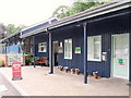
Office and reception, Abbey Wood Caravan Club site
Image: © Paul Shreeve
Taken: 16 Sep 2010
0.12 miles