IMAGES TAKEN NEAR TO
Knee Hill, LONDON, SE2 0AQ
Introduction
This page details the photographs taken nearby to Knee Hill, SE2 0AQ by members of the Geograph project.
The Geograph project started in 2005 with the aim of publishing, organising and preserving representative images for every square kilometre of Great Britain, Ireland and the Isle of Man.

There are currently over 7.5m images from over14,400 individuals and you can help contribute to the project by visiting https://www.geograph.org.uk
Image Map
Images are licensed for reuse under creativecommons.org/licenses/by-sa/2.0
Notes
- Clicking on the map will re-center to the selected point.
- The higher the marker number, the further away the image location is from the centre of the postcode.
Image Listing (64 Images Found)
Images are licensed for reuse under creativecommons.org/licenses/by-sa/2.0
Image
Details
Distance

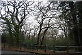
6
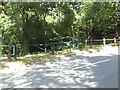
Entrance to Lesnes Abbey Wood
Only metres into Bexley borough on the east side of Knee Hill, this complex gate allows controlled entrance for walkers, pedal cyclists and permitted vehicles.
Image: © Stephen Craven
Taken: 14 Jul 2013
0.05 miles
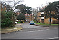
7
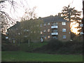
Hurst House, Abbey Wood
A low-rise housing block on the edge of Lesnes Abbey Wood. It takes its name from a Victorian villa that stood on or near this site.
Image: © Stephen Craven
Taken: 7 Dec 2008
0.05 miles
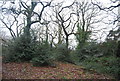
8
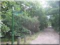
Green Chain Walk near Bostall House
The long distance walk leads along an access road (for the house) towards Knee Hill. It also heads right across Bostall Hill towards Bostall Woods.
Image: © David Anstiss
Taken: 7 Aug 2011
0.06 miles
9
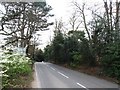
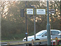
Vintage road signs on the A206, West Heath
Image: © Chris Whippet
Taken: 30 Mar 2014
0.06 miles
10
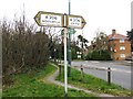
Old style roadsign
This type of signpost (black text in a white box on a yellow background) dates from the 1960s or earlier. The brown 'tourist' sign to Lesnes Abbey and the footpath marker for the Green Chain Walk are much newer.
Image: © Stephen Craven
Taken: 7 Dec 2008
0.06 miles