IMAGES TAKEN NEAR TO
Seymour Terrace, LONDON, SE20 8SA
Introduction
This page details the photographs taken nearby to Seymour Terrace, SE20 8SA by members of the Geograph project.
The Geograph project started in 2005 with the aim of publishing, organising and preserving representative images for every square kilometre of Great Britain, Ireland and the Isle of Man.

There are currently over 7.5m images from over14,400 individuals and you can help contribute to the project by visiting https://www.geograph.org.uk
Image Map
Images are licensed for reuse under creativecommons.org/licenses/by-sa/2.0
Notes
- Clicking on the map will re-center to the selected point.
- The higher the marker number, the further away the image location is from the centre of the postcode.
Image Listing (47 Images Found)
Images are licensed for reuse under creativecommons.org/licenses/by-sa/2.0
Image
Details
Distance
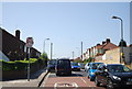
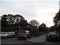
1
Seymour Terrace, Anerley
Built along the alignment of the former Croydon Canal, whose remaining portion lies in Betts Park behind the photographer. When the houses were built the canal was already disused. The access road runs along the former towpath.
Image: © Christopher Hilton
Taken: 19 May 2013
0.00 miles
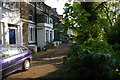
2

Seymour Terrace, Anerley
Built along the alignment of the former Croydon Canal, whose remaining portion lies in Betts Park over the railings. When the houses were built the canal was already disused. The access road runs along the former towpath.
Image: © Christopher Hilton
Taken: 19 May 2013
0.01 miles
3
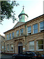
Anerley Town Hall
Anerley Vestry Hall was built in 1878 for conduct of public business of the district, then part of the Borough of Lewisham. It became the Town Hall when Penge Urban District Council was formed in 1900. In 1965, Anerley became part of the new London Borough of Bromley. It now houses Anerley Library, a playgroup, and other amenity groups, and is rented out as a venue for small theatre / drama productions, dancing, and other social functions such as wedding receptions.
Image: © Philip Talmage
Taken: 17 Aug 2005
0.04 miles
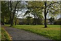
5
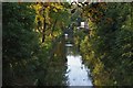
Betts Park, Anerley: last trace of the Croydon Canal
The Croydon Canal was built in the early nineteenth century, running from the Grand Surrey Canal north of the present New Cross Gate station, to a basin under the site of the present West Croydon station. As those details suggest, it was later bought by a railway company and much of its trackbed used by what became the London, Brighton and South Coast Railway's main line south. Where the canal swung off the straighter course of the railway it has largely been built over. Here in Anerley, however, the canal did an S-bend around some curves in the land whilst the later railway carved straight through them, and a short stretch of the canal survives a hundred yards or so off the railway line, converted to an ornamental lake in Betts Park. The only other surviving piece of canal infrastructure is its reservoir half a mile south-west of here, now South Norwood Lake and like this preserved by being in a park.
Image: © Christopher Hilton
Taken: 13 Oct 2009
0.08 miles
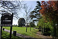
6
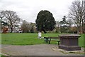
Memorials in Betts Park
The brick memorial lost its plaque many years ago by the look of it. The notice by the informal shrine in the mid frame is a police poster appealing for witnesses to a fatal stabbing in 2017.
Image: © Glyn Baker
Taken: 27 Mar 2019
0.10 miles
7
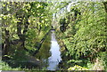
Croydon Canal, Betts Park
The Croydon Canal ran 9 miles from Croydon, via Forest Hill, to the Grand Surrey Canal at New Cross. It opened in 1809, and closed in 1836, making it the first canal to be formally abandoned by an Act of Parliament. This is the last remaining part of the canal.
Image: © N Chadwick
Taken: 9 Apr 2011
0.10 miles