IMAGES TAKEN NEAR TO
Stamford Street, LONDON, SE1 9NH
Introduction
This page details the photographs taken nearby to Stamford Street, SE1 9NH by members of the Geograph project.
The Geograph project started in 2005 with the aim of publishing, organising and preserving representative images for every square kilometre of Great Britain, Ireland and the Isle of Man.

There are currently over 7.5m images from over14,400 individuals and you can help contribute to the project by visiting https://www.geograph.org.uk
Image Map (Loading...)


Getting Data...Please wait
Leaflet Map data © OpenStreetMap
Images are licensed for reuse under creativecommons.org/licenses/by-sa/2.0
Notes
- Clicking on the map will re-center to the selected point.
- The higher the marker number, the further away the image location is from the centre of the postcode.
Image Listing (1620 Images Found)
Images are licensed for reuse under creativecommons.org/licenses/by-sa/2.0
Image
Details
Distance
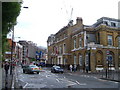
1
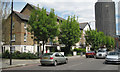
Flats, Stamford Street
The London A-Z atlas gives No.100, Mulberry Housing Co-operative in this location. The trees are believed to be Narrow-leaved Ash, Fraxinus oxycarpa; the autumn-colouring variety 'Raywood' is often planted as a street tree.
The tall building on the right is King's Reach Tower.
Image: © Robin Stott
Taken: 13 May 2012
0.01 miles
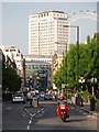
2
Coin Street, London
Looking in the direction of the London Television Centre.
Image: © Peter Trimming
Taken: 28 Mar 2010
0.02 miles
3
Stamford Street
Looking west from a vantage point by the Stamford Arms.
Image: © Patrick Mackie
Taken: 19 May 2010
0.03 miles
4
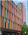
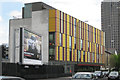
Coin Street Neighbourhood Centre
The Coin Street neighbourhood centre on Stamford Street provides community facilities and services to families in the area. Designed by Haworth Tompkins Architects.
Image: © Patrick Mackie
Taken: 30 Jun 2013
0.03 miles
5

The London Eye from The Shard, London SE1
Image: © Christine Matthews
Taken: 11 Apr 2014
0.03 miles
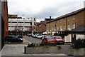
6
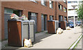
Structures outside flats, Coin Street, SE1
My working assumption is that these are detached pairs of bin stores and that a rubbish collection is expected.
Image: © Robin Stott
Taken: 13 May 2012
0.04 miles
7
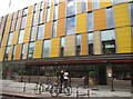
Coin Street Neighbourhood Centre
On the north side of Stamford Street, SE1. The tall building on the right is King's Reach Tower.
Image: © Robin Stott
Taken: 13 May 2012
0.04 miles
10
London Nautical School
Stamford Street looking east, with the London Nautical School on the right on the corner of Duchy Street. It moved here in 1965, occupying premises originally built in the 1820s as an orphanage and a chapel http://www.lns.org.uk/historical.htm .
Image: © Derek Harper
Taken: 19 May 2006
0.05 miles