IMAGES TAKEN NEAR TO
Coxwell Road, LONDON, SE19 3BG
Introduction
This page details the photographs taken nearby to Coxwell Road, SE19 3BG by members of the Geograph project.
The Geograph project started in 2005 with the aim of publishing, organising and preserving representative images for every square kilometre of Great Britain, Ireland and the Isle of Man.

There are currently over 7.5m images from over14,400 individuals and you can help contribute to the project by visiting https://www.geograph.org.uk
Image Map
Images are licensed for reuse under creativecommons.org/licenses/by-sa/2.0
Notes
- Clicking on the map will re-center to the selected point.
- The higher the marker number, the further away the image location is from the centre of the postcode.
Image Listing (309 Images Found)
Images are licensed for reuse under creativecommons.org/licenses/by-sa/2.0
Image
Details
Distance
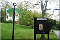
1
Institutional building by Westow Park, Upper Norwood, south London
It is first shown on an OS map of 1934-5, unlabelled. A map of 1967-82 shows it as 'Hostel' with blocks immediately to the north labelled 'Adult and Youth Centre'. They have been replaced by The Triangle, a children-focused community centre operated by the Barnardo's charity https://www.facebook.com/barnardosthetriangle/ The hostel still sits alongside it on the same site off Coxwell Road; it may be residential accommodation for children who have been removed from their families.
Image: © Robin Stott
Taken: 23 Mar 2018
0.02 miles
4
Northeast and uphill on Bedwardine Road, Upper Norwood, south London
Signed as a cul-de-sac, there is only a pedestrian connection with Haynes Lane. The area has a mixture of house-types of different periods.
Image: © Robin Stott
Taken: 23 Mar 2018
0.04 miles
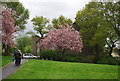
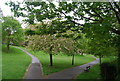
6
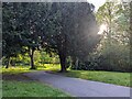
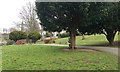
Westow Park path
A path in Westow Park with the late afternoon spring sun shining through the trees
Image: © PhotoMan9000
Taken: 30 Apr 2024
0.05 miles
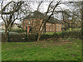
7
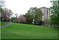
Westow Park, Norwood, south London
Westow Park occupies the steep slope on the southeast side of the Crystal Palace triangle. A map of 1875 shows that these were the grounds of a large house called The Mount, subsequently built on. The spire is of the little-photographed Greek Orthodox Church in Westow Street Image
Image: © Robin Stott
Taken: 23 Mar 2018
0.05 miles
8
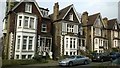
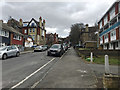
Victorian villas, Gatestone Road, SE19
Image: © Christopher Hilton
Taken: 21 Apr 2016
0.06 miles