IMAGES TAKEN NEAR TO
Lansdowne Place, LONDON, SE19 2UA
Introduction
This page details the photographs taken nearby to Lansdowne Place, SE19 2UA by members of the Geograph project.
The Geograph project started in 2005 with the aim of publishing, organising and preserving representative images for every square kilometre of Great Britain, Ireland and the Isle of Man.

There are currently over 7.5m images from over14,400 individuals and you can help contribute to the project by visiting https://www.geograph.org.uk
Image Map
Images are licensed for reuse under creativecommons.org/licenses/by-sa/2.0
Notes
- Clicking on the map will re-center to the selected point.
- The higher the marker number, the further away the image location is from the centre of the postcode.
Image Listing (342 Images Found)
Images are licensed for reuse under creativecommons.org/licenses/by-sa/2.0
Image
Details
Distance
4
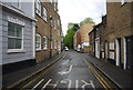
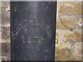
Boundary marker, Lansdowne Place, Upper Norwood
This little road running diagonally away from the Norwood triangle carries the boundary between the London Boroughs of Bromley and Croydon (previously between the counties of Kent and Surrey respectively). Unusually, the boundary runs not down the middle of the road, but along the property frontages on the north side of the road. The metal boundary post shown here carries the writing "Battersea 1854": at this time the land on the Kent side of the boundary (in this photograph, the building), later the Urban District of Penge, was a detached portion of the parish of Battersea, whilst that in which the photographer is standing was part of the parish of Croydon.
Image: © Christopher Hilton
Taken: 1 Jan 2011
0.03 miles
5
Boundary marker, Lansdowne Place, Upper Norwood
This little road running diagonally away from the Norwood triangle carries the boundary between the London Boroughs of Bromley and Croydon (previously between the counties of Kent and Surrey respectively). Unusually, the boundary runs not down the middle of the road, but along the property frontages on the north side of the road. The metal boundary post shown here carries the writing "Battersea 1854": at this time the land on the Kent side of the boundary (in this photograph, the building), later the Urban District of Penge, was a detached portion of the parish of Battersea, whilst that in which the photographer is standing was part of the parish of Croydon.
Image: © Christopher Hilton
Taken: 1 Jan 2011
0.03 miles
7
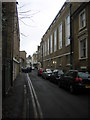
Lansdowne Place, Upper Norwood
This little road running diagonally away from the Norwood triangle carries the boundary between the London Boroughs of Bromley and Croydon (previously between the counties of Kent and Surrey respectively). Unusually, the boundary runs not down the middle of the road, but along the property frontages on the right of the road.
Image: © Christopher Hilton
Taken: 1 Jan 2011
0.03 miles
8
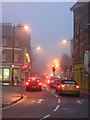
Misty evening, Norwood triangle
The junction shown here is the southern point of the Norwood triangle; Church Road leads on southwards to the parish church at the south end of the hill.
Image: © Christopher Hilton
Taken: 30 Dec 2010
0.03 miles
9
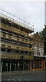
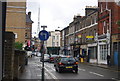
Construction at the junction of Westow St and Church Rd, SE19
For a picture of the small nineteenth-century cottages-cum-shops that this block replaces, see Image The block next door has been gentrified recently, with a Vietnamese restaurant replacing the chip shop.
Image: © Christopher Hilton
Taken: 5 Aug 2013
0.04 miles
10
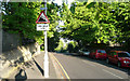
Fox Hill - Steep Hill 20%
Fox Hill, Crystal Palace. 20% steep hill down sign.
Image: © Adam Morse
Taken: 19 May 2009
0.04 miles