IMAGES TAKEN NEAR TO
Anerley Vale, LONDON, SE19 2BG
Introduction
This page details the photographs taken nearby to Anerley Vale, SE19 2BG by members of the Geograph project.
The Geograph project started in 2005 with the aim of publishing, organising and preserving representative images for every square kilometre of Great Britain, Ireland and the Isle of Man.

There are currently over 7.5m images from over14,400 individuals and you can help contribute to the project by visiting https://www.geograph.org.uk
Image Map
Images are licensed for reuse under creativecommons.org/licenses/by-sa/2.0
Notes
- Clicking on the map will re-center to the selected point.
- The higher the marker number, the further away the image location is from the centre of the postcode.
Image Listing (429 Images Found)
Images are licensed for reuse under creativecommons.org/licenses/by-sa/2.0
Image
Details
Distance
1
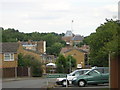
Upper Norwood: Chipstead Close and Crystal Palace station
The housing association flats here were built after some dilapidated Victorian terraces were cleared in the 1970s. At the same time, roads that had run straight through the area were converted to slightly curved culs-de-sac. Chipstead Close is the southern half of a road that used to run through to the Paxton Arms, whose white-painted side can be seen in the middle distance. Beyond, on the other side of Anerley Hill, is the pointed roof of Crystal Palace station.
Image: © Christopher Hilton
Taken: 8 Aug 2010
0.03 miles
2
View of the Anerley TV transmission mast from Waldegrave Road
Looking west-southwest.
Image: © Robert Lamb
Taken: 14 Jul 2011
0.04 miles
3
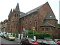
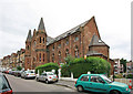
Church Court, Waldegrave Road, London SE19
Formerly a church now converted into apartments
Image: © Robin Sones
Taken: 31 Aug 2006
0.04 miles
4
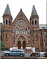
Svedborgian church, Waldegrave Road, London SE19
This is now an apartment block, but previously was a church, the New Svedborgian church.
Image: © John Salmon
Taken: 12 Jul 2010
0.05 miles

7
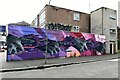
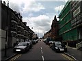
Street art, Anerley Vale, Crystal Palace
Photo number 7508157.
Image: © Robin Stott
Taken: 22 May 2023
0.05 miles
8
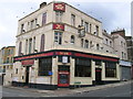
The Paxton Arms Hotel, 52 Anerley Hill, London SE19
Junction of Anerley Hill and Palace Road
Image: © Robin Sones
Taken: 31 Aug 2006
0.05 miles
9
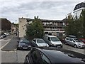
Miller House, Anerly Vale, Crystal Palace
Seen from the rear, these are flats above a row of shops that face Anerly Road A214.
Image: © Robin Stott
Taken: 12 Oct 2018
0.05 miles
10
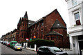
Anerley: New Church Court
This is now an apartment block, but previously was a church, the New Swedenborgian (or Svedborgian) church. For more information see wikipedia http://en.wikipedia.org/wiki/The_New_Church and http://en.wikipedia.org/wiki/Emanuel_Swedenborg . Swedenborg's writings had considerable influence on William Blake.
The building dates from 1883.
Image: © Dr Neil Clifton
Taken: 9 Mar 2010
0.05 miles