IMAGES TAKEN NEAR TO
Jasper Road, LONDON, SE19 1SJ
Introduction
This page details the photographs taken nearby to Jasper Road, SE19 1SJ by members of the Geograph project.
The Geograph project started in 2005 with the aim of publishing, organising and preserving representative images for every square kilometre of Great Britain, Ireland and the Isle of Man.

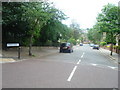
There are currently over 7.5m images from over14,400 individuals and you can help contribute to the project by visiting https://www.geograph.org.uk
Image Map
Images are licensed for reuse under creativecommons.org/licenses/by-sa/2.0
Notes
- Clicking on the map will re-center to the selected point.
- The higher the marker number, the further away the image location is from the centre of the postcode.
Image Listing (515 Images Found)
Images are licensed for reuse under creativecommons.org/licenses/by-sa/2.0
Image
Details
Distance
2
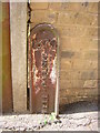
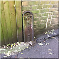
Boundary marker, Jasper Passage
The wall and land beyond it lay in Camberwell Parish when the marker was erected, the photographer and land behind in Lambeth. The same boundary persists today, dividing the London Boroughs of Southwark and Lambeth respectively.
Image: © Christopher Hilton
Taken: 27 Jun 2009
0.04 miles
3
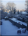
Snow at last in South London, 28 February 2018
The sun is shining in Upper Sydenham and Dulwich, seen from the heights of Crystal Palace/Upper Norwood. On a clear day you can see the City.
Image: © Philippa Riley
Taken: 28 Feb 2018
0.04 miles
4
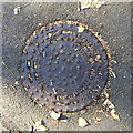
Round cast iron inspection cover, Farquhar Road, Upper Norwood, southeast London
Text in raised lettering: J. STONE & Co. Ltd. | DEPTFORD. LONDON. SE. | PATENT No. 24219/09
Outside a relatively new brick house, across the road from Bowley Lane.
Image: © Robin Stott
Taken: 11 Oct 2018
0.05 miles
5
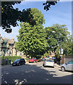
Northwest and downhill on Jasper Road, Crystal Palace, south London
Crystal Palace village is on a summit. All the approaches are steep. The camera position is close to that for Image
Image: © Robin Stott
Taken: 28 Aug 2017
0.05 miles
6
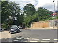
Precipitous double-dogleg Jasper Road, Upper Norwood, south London
On the right are the backs of houses in Farquhar Road. A short spur of Jasper Road climbs steeply to meet Image Jasper Road continues steeply uphill behind the camera to meet Westow Hill Image It meets up with Farquhar Road again downhill.
Image: © Robin Stott
Taken: 14 Jul 2018
0.05 miles
7
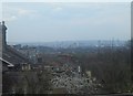
Jasper Road, SE19: view over the rooftops to the city
Image: © Christopher Hilton
Taken: 10 Apr 2008
0.05 miles
8
Cast iron parish boundary marker, Jasper Passage, Upper Norwood, southeast London
Dated 1870, its lower part is now below the paved surface but it appears to denote Camberwell Parish and perhaps responsibility for this urban footpath. It's assumed to mark a boundary: the boundaries of four modern boroughs meet up on the Crystal Palace hill: Bromley, Croydon, Lambeth and Southwark, which takes in Camberwell.
Image: © Robin Stott
Taken: 11 Oct 2018
0.06 miles
9
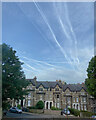
Contrails over Upper Norwood, London
A few years ago, visits to family in Camberwell left a memory of the soundscape – sirens of ambulances heading for King's College Hospital, and the roar of low-flying passenger jets heading for Heathrow. Perhaps the airspace became congested because, the family having moved to Crystal Palace, the jets followed, though higher-flying over the hill, thankfully. This early morning view is towards precipitous Jasper Road.
Image: © Robin Stott
Taken: 21 May 2022
0.06 miles
10
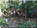
Conservation Volunteers? base, Dulwich Upper Wood, Farquhar Road, Upper Norwood
The wall incorporates what I believe are mini-habitats for insects and other small creatures.
Facebook: /dulwichupper.wood
Twitter: @dulwichuwood
The Conservation Volunteers: www.tcv.org.uk
Image: © Robin Stott
Taken: 10 Oct 2018
0.06 miles