IMAGES TAKEN NEAR TO
Woodland Road, LONDON, SE19 1PQ
Introduction
This page details the photographs taken nearby to Woodland Road, SE19 1PQ by members of the Geograph project.
The Geograph project started in 2005 with the aim of publishing, organising and preserving representative images for every square kilometre of Great Britain, Ireland and the Isle of Man.

There are currently over 7.5m images from over14,400 individuals and you can help contribute to the project by visiting https://www.geograph.org.uk
Image Map
Images are licensed for reuse under creativecommons.org/licenses/by-sa/2.0
Notes
- Clicking on the map will re-center to the selected point.
- The higher the marker number, the further away the image location is from the centre of the postcode.
Image Listing (300 Images Found)
Images are licensed for reuse under creativecommons.org/licenses/by-sa/2.0
Image
Details
Distance
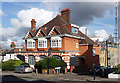
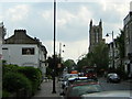
2
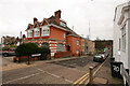
Cawnpore Street, SE19, and "The Railway Bell" pub
Taken from the corner of Cawnpore Street and Gipsy Hill, under a large prominent sign that directs people off the main road to the Railway Bell, which can be seen in the middle distance.
Image: © Christopher Hilton
Taken: 21 Apr 2011
0.02 miles
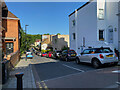
3
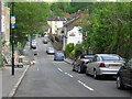
Approaching the lower end of Woodland Road, Crystal Palace
Woodland Road zigzags down from Westow Hill to join Gipsy Hill, just up from the station. Long before the Crystal Palace there was extensive woodland on the hill: the Great North Wood is remembered in the name Norwood.
Image: © Robin Stott
Taken: 19 May 2022
0.02 miles
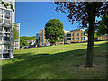
4
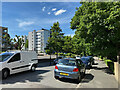
Playspace, Cawnpore Street, Crystal Palace
Surrounded by blocks of flats. Not very busy at 10am on a Sunday morning. Cawnpore Street runs between Gipsy Hill and Woodland Road.
Image: © Robin Stott
Taken: 5 Sep 2021
0.03 miles
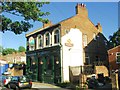
5
72-74 Gipsy Hill
A jolly Arts-and-Craft-influenced building, now offices and flats, of orange brick with stone bands and decorative windows on the ground floor.
Information from Lambeth Council: "former French's Dairy ... the cows grazed in French's Field at the bottom of Gipsy Hill and were driven up to the diary for milking. The milking sheds were behind in Cawnpore Street."
The new flats behind, down Cawnpore Street, were built on the site of a car mechanic's workshop.
The Crystal Palace television mast is in the background.
Image: © Stephen Richards
Taken: 16 Feb 2011
0.03 miles
7
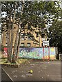
Flats, east side of Gipsy Hill
Across the green is Woodland Road.
Image: © Robin Stott
Taken: 14 May 2022
0.04 miles
9
Gipsy Hill: sign for "The Railway Bell" pub
The Railway Bell is some way down Cawnpore Street; to make sure no-one passes by unaware of it, a large sign points the way where the street meets Gipsy Hill.
Image: © Christopher Hilton
Taken: 21 Apr 2011
0.05 miles
10
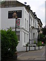
Gipsy Hill: sign for "The Railway Bell" pub
The Railway Bell is some way down Cawnpore Street; to make sure no-one passes by unaware of it, a large sign points the way where the street meets Gipsy Hill.
Image: © Christopher Hilton
Taken: 21 Apr 2011
0.05 miles