IMAGES TAKEN NEAR TO
Gibbs Square, LONDON, SE19 1JN
Introduction
This page details the photographs taken nearby to Gibbs Square, SE19 1JN by members of the Geograph project.
The Geograph project started in 2005 with the aim of publishing, organising and preserving representative images for every square kilometre of Great Britain, Ireland and the Isle of Man.

There are currently over 7.5m images from over14,400 individuals and you can help contribute to the project by visiting https://www.geograph.org.uk
Image Map
Images are licensed for reuse under creativecommons.org/licenses/by-sa/2.0
Notes
- Clicking on the map will re-center to the selected point.
- The higher the marker number, the further away the image location is from the centre of the postcode.
Image Listing (97 Images Found)
Images are licensed for reuse under creativecommons.org/licenses/by-sa/2.0
Image
Details
Distance
1
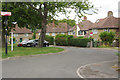
Gibbs Square, Norwood
In 1924 Lambeth Borough Council acquired 18.5 acres of land on a hilly site for building 318 dwellings. The Bloomfield Estate, built in the 'garden city' style was completed in 1927; Gibbs Square where the houses surround a central green is a good example of the planning concept.
Image: © Stephen McKay
Taken: 6 Sep 2018
0.03 miles
2
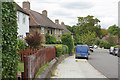
Bloomhall Road, Norwood
Bloomhall Road is part of the Bloomfield Estate built by Borough of Lambeth in the mid-1920s in the 'garden city' style.
Image: © Stephen McKay
Taken: 6 Sep 2018
0.05 miles
3
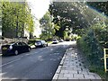
Southwest and uphill on Salter's Hill, Norwood
Image: © Robin Stott
Taken: 19 May 2022
0.05 miles
4
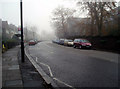
A misty day at Central Hill, Upper Norwood
To the right of the line of parked cars is the chapel of Virgo Fidelis RC Girls' School, in which a funeral is taking place. The December weather seems to be mournfully in tune with the occasion.
Image: © Dr Neil Clifton
Taken: 9 Dec 2005
0.05 miles
5
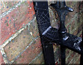
A web on the gate
The condensation caused by cold weather picks out a cobweb on the gate of Virgo Fidelis School
Image: © Dr Neil Clifton
Taken: 9 Dec 2005
0.05 miles
6
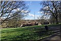
Salter's Hill, Norwood, and Crystal Palace transmitter seen from Norwood Park
Breezy Norwood Park has the elevation to command a superb view of London to the north Image Sunshine and shadow on monopitched roofs creates a sawtoothed effect on Salter's Hill.
Image: © Robin Stott
Taken: 6 Mar 2020
0.05 miles
7
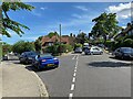
Junction of Bloomhall Road and Durning Road, Norwood
Bloomhall Road heads up and over the hill; Durning road heads down and rejoins it.
Image: © Robin Stott
Taken: 19 May 2022
0.05 miles
8
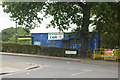
Hungry Hippo Cafe, Norwood Park
This building on Salter's Hill would look unprepossessing without the graffiti, with the graffiti it is a real eyesore. However, it provides a facility for visitors to Norwood Park and the Friends of Norwood Park website says it: 'is run by Athraa and features a new indoor seating area for use all year round!'
Image: © Stephen McKay
Taken: 6 Sep 2018
0.06 miles
9
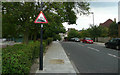
Salter's Hill - Steep Hill 10%
Salter's Hill, Crystal Palace. 10% steep hill down sign.
Image: © Adam Morse
Taken: 8 Aug 2009
0.06 miles
10
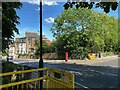
Postbox SE19 42, Salter's Hill, Norwood
Seen from Norwood Park at the corner of Bloomhall Road.
Image: © Robin Stott
Taken: 19 May 2022
0.06 miles