IMAGES TAKEN NEAR TO
Oakwood Drive, LONDON, SE19 1EZ
Introduction
This page details the photographs taken nearby to Oakwood Drive, SE19 1EZ by members of the Geograph project.
The Geograph project started in 2005 with the aim of publishing, organising and preserving representative images for every square kilometre of Great Britain, Ireland and the Isle of Man.

There are currently over 7.5m images from over14,400 individuals and you can help contribute to the project by visiting https://www.geograph.org.uk
Image Map
Images are licensed for reuse under creativecommons.org/licenses/by-sa/2.0
Notes
- Clicking on the map will re-center to the selected point.
- The higher the marker number, the further away the image location is from the centre of the postcode.
Image Listing (195 Images Found)
Images are licensed for reuse under creativecommons.org/licenses/by-sa/2.0
Image
Details
Distance
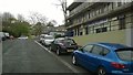
1
Central Hill Estate, SE19: looking along Northwood Way
Image: © Christopher Hilton
Taken: 22 Apr 2016
0.01 miles
2
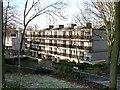
Housing estate, Central Hill
One block of a development by Lambeth council in 1967-74 (in the days when local authorities employed architects and built public housing). Pevsner comments that it is "stylistically still very much in the International Modern tradition...with ingenious planning it was possible to give all the flats front doors at ground level, reached by paths along the contours of the hill". The other side affords excellent views towards central London.
Image: © Stephen Richards
Taken: Unknown
0.01 miles
4
Central Hill estate ? 41-50 Northwood Way and High Limes
Image: © Robin Stott
Taken: 19 May 2022
0.03 miles
5
Central Hill Estate, SE19: looking along Hawke Road
Image: © Christopher Hilton
Taken: 22 Apr 2016
0.03 miles
6
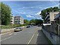
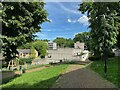
Central Hill estate ? southeast end of Hawke Road
It rises rather sharply to meet Lunham Road. On the right are the boundaries of Northwood Way properties 41-50. Beyond them is the block of flats called High Limes. On the left is the block of flats called Pear Tree House which, although it has a family resemblance to Central Hill estate, it doesn't appear on the displayed estate plan Image
Image: © Robin Stott
Taken: 19 May 2022
0.03 miles
7
Central Hill Estate, SE19: looking along Hawke Road
Image: © Christopher Hilton
Taken: 22 Apr 2016
0.03 miles
8
Central Hill Estate, SE19: looking along Hawke Road
Image: © Christopher Hilton
Taken: 22 Apr 2016
0.03 miles
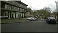
9
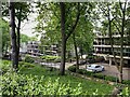
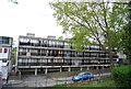
Central Hill estate ? blocks of flats along Oakwood Drive
On the right is City Prospect and ahead at a lower level is Valley Prospect; they each consist of 30 flats. Between them runs the south end of Lunham Road. The view is from Central Hill.
Image: © Robin Stott
Taken: 19 May 2022
0.04 miles
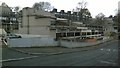
10
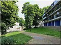
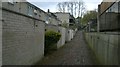
Central Hill estate ? change of level below London Prospect
The path by Wychwood Way drops down to 41-50 Northwood Way. A path somewhere leads to 37-46 Wychwood Way beyond the trees. The London Prospect block looks out over the scene; the ground 'floor' is for parking.
Image: © Robin Stott
Taken: 19 May 2022
0.04 miles