IMAGES TAKEN NEAR TO
South Rise Way, LONDON, SE18 7PG
Introduction
This page details the photographs taken nearby to South Rise Way, SE18 7PG by members of the Geograph project.
The Geograph project started in 2005 with the aim of publishing, organising and preserving representative images for every square kilometre of Great Britain, Ireland and the Isle of Man.

There are currently over 7.5m images from over14,400 individuals and you can help contribute to the project by visiting https://www.geograph.org.uk
Image Map
Images are licensed for reuse under creativecommons.org/licenses/by-sa/2.0
Notes
- Clicking on the map will re-center to the selected point.
- The higher the marker number, the further away the image location is from the centre of the postcode.
Image Listing (73 Images Found)
Images are licensed for reuse under creativecommons.org/licenses/by-sa/2.0
Image
Details
Distance
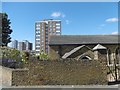
2
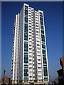
Plumstead: River Heights, 179-359 Glyndon Road, SE18
One of a pair of recently refurbished 72 metres high, 24 floor, residential tower blocks that were completed in 1970. The other one is behind the photographer in Elmley Street.
Image: © Nigel Cox
Taken: 26 Mar 2007
0.07 miles
3
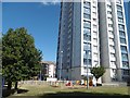
River Heights, Earl Rise, Plumstead
The tower block is known as River Heights. The sign outside says it is a tenant management co-operative.
Image: © Marathon
Taken: 8 Sep 2016
0.07 miles
4
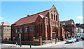
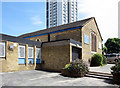
Corner Conway Road & Griffin Road, SE18
This building appears to be a church which has been adapted for alternative use.
Image: © John Salmon
Taken: 9 Jul 2010
0.08 miles
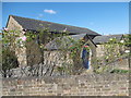
5
St John, Earl Rise, Plumstead, London SE18
Image: © John Salmon
Taken: 9 Jul 2010
0.09 miles
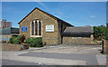
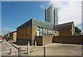
6
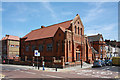
St John's Church, Earl Rise, Plumstead
St John's Church was built in 1959 within the ruined walls of an earlier, possibly Victorian, church which was bombed during the Second World War and badly damaged. The ruins were mostly demolished after the War and the new church used what may have been parts of the transept and chancel walls of the former church. It consists of a simple rectangular nave and chancel orientated north to south, with two separate extensions attached to the east wall forming the vestry and a library. A church hall forms an extension to the west in what may have been the former nave. This view is from the south-east.
Image: © Marathon
Taken: 8 Sep 2016
0.10 miles
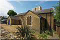
7
St John, Earl Rise, Plumstead, London SE18
Image: © John Salmon
Taken: 9 Jul 2010
0.10 miles
8
St John, Earl Rise, Plumstead, London SE18
Image: © John Salmon
Taken: 9 Jul 2010
0.11 miles
9
St John' Church, Earl Rise, Plumstead
St John's Church was built in 1959 within the ruined walls of an earlier, possibly Victorian, church which was bombed during the Second World War and badly damaged. The ruins were mostly demolished after the War and the new church used what may have been parts of the transept and chancel walls of the former church. It consists of a simple rectangular nave and chancel orientated north to south, with two separate extensions attached to the east wall forming the vestry and a library. A church hall forms an extension to the west in what may have been the former nave.
As can be seen it is surrounded by tower blocks and there is another overshadowing the church to the north-east - see http://www.geograph.org.uk/photo/4810562
Image: © Marathon
Taken: 8 Sep 2016
0.11 miles
10
St John, Earl Rise, Plumstead, London SE18
Image: © John Salmon
Taken: 9 Jul 2010
0.11 miles