IMAGES TAKEN NEAR TO
Burrage Road, LONDON, SE18 7JU
Introduction
This page details the photographs taken nearby to Burrage Road, SE18 7JU by members of the Geograph project.
The Geograph project started in 2005 with the aim of publishing, organising and preserving representative images for every square kilometre of Great Britain, Ireland and the Isle of Man.

There are currently over 7.5m images from over14,400 individuals and you can help contribute to the project by visiting https://www.geograph.org.uk
Image Map
Images are licensed for reuse under creativecommons.org/licenses/by-sa/2.0
Notes
- Clicking on the map will re-center to the selected point.
- The higher the marker number, the further away the image location is from the centre of the postcode.
Image Listing (62 Images Found)
Images are licensed for reuse under creativecommons.org/licenses/by-sa/2.0
Image
Details
Distance
3
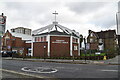
Former St James church, Plumstead
The conversion shown in Image is now complete and this former church is now apartments for sale or letting.
Image: © Stephen Craven
Taken: 21 Jul 2007
0.06 miles
4
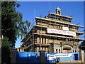
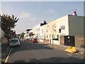
Conversion nearly complete
The former church of St James, Plumstead on Burrage Road. From 1966-2003 it was used as a theatre but has recently been converted to apartments.
Image: © Stephen Craven
Taken: 14 Jul 2005
0.07 miles
6
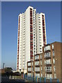
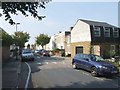
High rise flats, Plumstead
Low rise and high rise blocks of flats in Plumstead, South East London.
Image: © Malc McDonald
Taken: 22 Oct 2011
0.11 miles
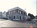
9
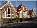
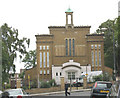
Bloomfield Road School
This is the west elevation, showing the single-storey buildings facing Sandy Hill Road. The larger three-storey building (east side) faces Bloomfield Road itself. It is typical of dozens of Board School erected in London during the last quarter of the nineteenth century and the first decade of the twentieth century. Its use and status have changed many times over the years. For example in the 1950s it was a boys 'central school' (i.e. midway between a grammar and a secondary modern). In the 1930s, however, it was a mixed elementary school, with pupils aged 11-14.
Image: © Chris Martyn
Taken: 30 Jun 2006
0.14 miles