IMAGES TAKEN NEAR TO
Bloomfield Road, LONDON, SE18 7JN
Introduction
This page details the photographs taken nearby to Bloomfield Road, SE18 7JN by members of the Geograph project.
The Geograph project started in 2005 with the aim of publishing, organising and preserving representative images for every square kilometre of Great Britain, Ireland and the Isle of Man.

There are currently over 7.5m images from over14,400 individuals and you can help contribute to the project by visiting https://www.geograph.org.uk
Image Map
Images are licensed for reuse under creativecommons.org/licenses/by-sa/2.0
Notes
- Clicking on the map will re-center to the selected point.
- The higher the marker number, the further away the image location is from the centre of the postcode.
Image Listing (59 Images Found)
Images are licensed for reuse under creativecommons.org/licenses/by-sa/2.0
Image
Details
Distance
3
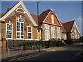
Bloomfield Road School
This is the west elevation, showing the single-storey buildings facing Sandy Hill Road. The larger three-storey building (east side) faces Bloomfield Road itself. It is typical of dozens of Board School erected in London during the last quarter of the nineteenth century and the first decade of the twentieth century. Its use and status have changed many times over the years. For example in the 1950s it was a boys 'central school' (i.e. midway between a grammar and a secondary modern). In the 1930s, however, it was a mixed elementary school, with pupils aged 11-14.
Image: © Chris Martyn
Taken: 30 Jun 2006
0.08 miles
5
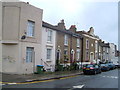
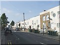
Invicta Terrace, Sandy Hill Road, Woolwich
The central section of the mid-nineteenth century terrace with the rounded pediment feature carries the name "Invicta Terrace".
Image: © Derek Harper
Taken: 19 May 2006
0.12 miles
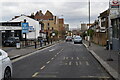
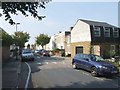
8
Elmdene Road, SE18
Earlier called Hanover Road. Was the named changed because of anti-German sentiment?
Image: © Robin Webster
Taken: 14 Mar 2012
0.13 miles

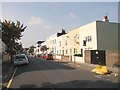
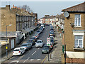
10
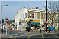
Corner shop, Woolwich
Dealing in African, Caribbean and Chino-Vietnamese foods.
Image: © Robin Webster
Taken: 14 Mar 2012
0.14 miles