IMAGES TAKEN NEAR TO
Walpole Place, LONDON, SE18 6TW
Introduction
This page details the photographs taken nearby to Walpole Place, SE18 6TW by members of the Geograph project.
The Geograph project started in 2005 with the aim of publishing, organising and preserving representative images for every square kilometre of Great Britain, Ireland and the Isle of Man.

There are currently over 7.5m images from over14,400 individuals and you can help contribute to the project by visiting https://www.geograph.org.uk
Image Map
Images are licensed for reuse under creativecommons.org/licenses/by-sa/2.0
Notes
- Clicking on the map will re-center to the selected point.
- The higher the marker number, the further away the image location is from the centre of the postcode.
Image Listing (247 Images Found)
Images are licensed for reuse under creativecommons.org/licenses/by-sa/2.0
Image
Details
Distance
1
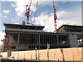
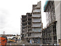
Large construction site on Anglesea Road, Woolwich
This large development (between Anglesea Road and Brookhill Road) replaces a block of flats (built in the 60's) called Walpole Place.
See http://www.walpoleplace.co.uk/AboutUs.html for more about the estate known for its crime and anti-social behaviour problems.
Image: © David Anstiss
Taken: 15 Feb 2012
0.02 miles
2
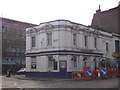
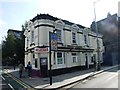
Anglesea Arms, Public House, Woolwich
Shepherd Neame Pub on the junction of Anglesea Avenue (on the left) and Anglesea Road (on the right).
Image: © David Anstiss
Taken: 15 Feb 2012
0.03 miles
3
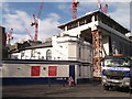
Development overshading Anglesea Arms
In the foreground is a Shepherd Neame Pub on Anglesea Avenue.
In the background is the new large development site on Anglesea Road, this replaces a block of flats called Walpole Place.
Image: © David Anstiss
Taken: 15 Feb 2012
0.03 miles
4
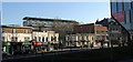
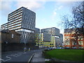
Woolwich New Road
The A205, with Anglesea Road turning off in the centre. The block behind is Walpole Place, built in 1965-6. On the right is a corner of the Woolwich Central development; see also Image
Image: © Derek Harper
Taken: 24 Feb 2019
0.04 miles
5
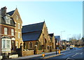
Woolwich, SE18
Looking out onto the junction formed by Woolwich New Road (on which the van is parked) and Grand Depot Road are the Presbytery, the Roman Catholic Church of St Peter the Apostle and a former Roman Catholic School (now a Church Centre). The church is a Grade II-listed building that was designed by Augustus W.N.Pugin in 1843. The main shopping centre is on the left, whilst Woolwich Barracks is reached by Woolwich New Road using the One Way system in place.
Image: © David Hallam-Jones
Taken: 1 Jan 2013
0.05 miles
7
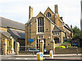
St Peter's Centre, Woolwich
The hall adjacent to the church of the same name.
Image: © Stephen Craven
Taken: 20 Sep 2008
0.06 miles
8
Woolwich town centre demolition
An eight-storey building being demolished to make way for the new Tesco development in the town centre. Part of the new build can be seen to the right of the photo.
I have not found a view of this building prior to demolition.
Image: © Stephen Craven
Taken: 3 Dec 2011
0.07 miles
9
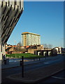
Tesco comes to Woolwich
These flats were built as part of a massive Tesco development in the centre of Woolwich which opened in November 2012. Seen here looking down Woolwich New Road, they totally dominate the largely Victorian scale town centre. I personally think they are hideous.
Image: © Marathon
Taken: 11 Jan 2014
0.07 miles
10
Woolwich, SE18
This pedestrian is walking along Woolwich New Road towards the town centre. Maritime House, a contemporary apartment complex in Green's End, can be seen in the distance.
Image: © David Hallam-Jones
Taken: 1 Jan 2013
0.07 miles