IMAGES TAKEN NEAR TO
Caldwell Close, LONDON, SE18 6FX
Introduction
This page details the photographs taken nearby to Caldwell Close, SE18 6FX by members of the Geograph project.
The Geograph project started in 2005 with the aim of publishing, organising and preserving representative images for every square kilometre of Great Britain, Ireland and the Isle of Man.

There are currently over 7.5m images from over14,400 individuals and you can help contribute to the project by visiting https://www.geograph.org.uk
Image Map
Images are licensed for reuse under creativecommons.org/licenses/by-sa/2.0
Notes
- Clicking on the map will re-center to the selected point.
- The higher the marker number, the further away the image location is from the centre of the postcode.
Image Listing (63 Images Found)
Images are licensed for reuse under creativecommons.org/licenses/by-sa/2.0
Image
Details
Distance
1
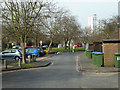
Gunner Lane, Woolwich
Within the housing development on the site of the former military hospital here.
Image: © Robin Webster
Taken: 14 Mar 2012
0.04 miles
2
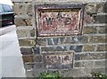
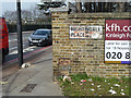
Old Boundary Marker by Nightingale Place, Woolwich
Estate Boundary Marker - War Department by the UC road, in parish of Woolwich (Greenwich District), Nightingale Place SE18, at junction Grand Depot Road, set in wall.
Surveyed
Milestone Society National ID: KE_WDWOO01em.
Image: © Milestone Society
Taken: Unknown
0.04 miles
3
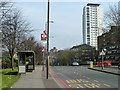
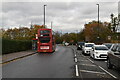
Bus stop S, Nightingale Place, Woolwich
Named Woolwich Common, and served by route 244 towards Shooters Hill.
Image: © Robin Webster
Taken: 14 Mar 2012
0.04 miles
4
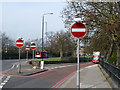
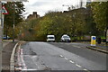
No entry to Woolwich New Road
At the junction with Grand Depot Road.
Image: © Robin Webster
Taken: 14 Mar 2012
0.04 miles
6
War Department boundary marker no. 1, Woolwich
There was a lot of military property in Woolwich, this was a military hospital, the site now sold off for housing. Nightingale Place probably takes its name from Florence Nightingale.
Image: © Robin Webster
Taken: 14 Mar 2012
0.05 miles
9
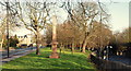
Woolwich Common Area, SE18
This wedge-shaped plot of land hosts two military related monuments. In the foreground is this Boer War memorial to the Officers and Men of the 61st Battery of the Royal Field Artillery who died in South Africa between 1899-1902 and behind it, albeit hidden by the trees, the ruins of St George's Garrison Church. The church was built in the 1860s to serve the Royal Artillery Barracks, part of which is visible on the left hand side of the picture. The right-hand road is Woolwich New Rd, that joins Grand Depot Rd (the A205) behind the photographer. Both roads connect Woolwich Common and Woolwich Arsenal.
Image: © David Hallam-Jones
Taken: 1 Jan 2013
0.07 miles
10
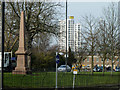
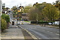
War memorial, Woolwich
Between Woolwich New Road and Grand Depot Road.
Image: © Robin Webster
Taken: 14 Mar 2012
0.07 miles