IMAGES TAKEN NEAR TO
Harlinger Street, LONDON, SE18 5SR
Introduction
This page details the photographs taken nearby to Harlinger Street, SE18 5SR by members of the Geograph project.
The Geograph project started in 2005 with the aim of publishing, organising and preserving representative images for every square kilometre of Great Britain, Ireland and the Isle of Man.

There are currently over 7.5m images from over14,400 individuals and you can help contribute to the project by visiting https://www.geograph.org.uk
Image Map
Images are licensed for reuse under creativecommons.org/licenses/by-sa/2.0
Notes
- Clicking on the map will re-center to the selected point.
- The higher the marker number, the further away the image location is from the centre of the postcode.
Image Listing (105 Images Found)
Images are licensed for reuse under creativecommons.org/licenses/by-sa/2.0
Image
Details
Distance
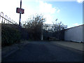
1
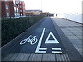
Misleading cycle lane
For anyone walking or cycling the Thames Path westwards from Woolwich this is a misleading marking: they should have turned left at this point onto a permanent diversion, though it is not signed as such. The path comes to an abrupt end 60 metres further on: Image The two cyclists visible in this picture had just made that mistake.
Image: © Stephen Craven
Taken: 16 Feb 2014
0.03 miles

3

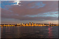
Crane Reflections on The Thames at Sunset
The red warning lights for aircraft made colourful reflections in the calm river.
Image: © Christine Matthews
Taken: 2 Oct 2014
0.05 miles
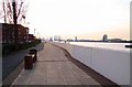
4
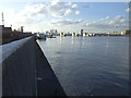
River wall at Harlinger Street
The upper level here is the Thames flood defences, equivalent to the top of the Thames barrier gates; the lower level is the original river wall. The photo taken roughly at mid-tide.
Image: © Stephen Craven
Taken: 16 Feb 2014
0.06 miles
5
The Thames at Sunset
As well as the afterglow of the sunset, the moon was peeping through the clouds.
Image: © Christine Matthews
Taken: 2 Oct 2014
0.06 miles
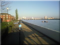
6
Thames Path: dead end
For anyone walking or cycling the Thames Path westwards from Woolwich for the first time there is a surprise: it comes to a dead end, within sight of the Thames Barrier 600m upstream, but with a not-very-well signed diversion of 1.6km to get there. Attempts by local campaigners and Sustrans to get the "missing link" completed have so far failed.
Image: © Stephen Craven
Taken: 16 Feb 2014
0.07 miles
8
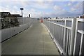
Thames Path at Woolwich Dockyard
This view along the riverside walkway is taken from the top of the footbridge seen in http://www.geograph.org.uk/photo/2357090 The route ahead is followed by both the Thames Path and Capital Ring. Canary Wharf can be seen in the distance, just to the right of the signpost.
Image: © Marathon
Taken: 8 Apr 2011
0.08 miles