IMAGES TAKEN NEAR TO
Marine Drive, LONDON, SE18 5SD
Introduction
This page details the photographs taken nearby to Marine Drive, SE18 5SD by members of the Geograph project.
The Geograph project started in 2005 with the aim of publishing, organising and preserving representative images for every square kilometre of Great Britain, Ireland and the Isle of Man.

There are currently over 7.5m images from over14,400 individuals and you can help contribute to the project by visiting https://www.geograph.org.uk
Image Map
Images are licensed for reuse under creativecommons.org/licenses/by-sa/2.0
Notes
- Clicking on the map will re-center to the selected point.
- The higher the marker number, the further away the image location is from the centre of the postcode.
Image Listing (74 Images Found)
Images are licensed for reuse under creativecommons.org/licenses/by-sa/2.0
Image
Details
Distance
1
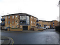
Housing on Mulgrave Road
A crescent of contemporary low-rise buildings.
Image: © Stephen Craven
Taken: 15 Dec 2012
0.06 miles
2
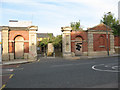
Red barracks gates
The gates, gatehouse and wall are all that remains of the former Red Barracks in Woolwich. They are grade 2 listed but on the "buildings at risk register".
Image: © Stephen Craven
Taken: 20 Sep 2008
0.06 miles
3
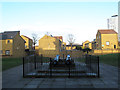
Cannon at the Red Barracks
These two cannon, along with some of the boundary walls Image, have been left as a reminder of the site's military history, though it has otherwise been developed for housing.
Image: © Stephen Craven
Taken: 19 Feb 2012
0.07 miles
4
Wall of former barracks
The wall adjacent to Image
Image: © Stephen Craven
Taken: 20 Sep 2008
0.08 miles
5
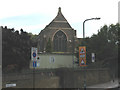
Church of Pentecost UK Jubilee Temple, Woolwich
This church, which is grade 2 listed, was formerly St Michael & All Angels, a daughter church in the parish of St Mary's, Woolwich Image It closed as a place of worship in 2014 and sold to a Ghanaian pentecostal church.
Image: © Stephen Craven
Taken: 20 Sep 2008
0.10 miles
6
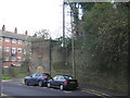
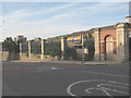
Former barracks wall, Borgard Road, Woolwich
Along the east side of Borgard Road and then eastwards parallel to the railway, massive brick walls mark the site of a nineteenth century structure: presumably this is part of the wall around the Red Barracks, whose gates are at the top of the hill (see Image).
Image: © Christopher Hilton
Taken: 20 Jan 2016
0.11 miles
8
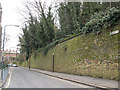
Borgard Road, Woolwich
The high retaining wall on the right of the photo marks the northern boundary of the former Red Barracks site (now occupied by housing). To the left (north) of the road are St Michael's church and Cardwell School's playground.
Image: © Stephen Craven
Taken: 4 Mar 2010
0.12 miles
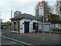
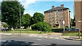
10
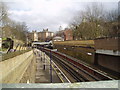
Woolwich Dockyard station
The station is in a cutting in what is primarily a residential gridsquare, with some very pleasant parkland at the southern edge.
Image: © Dr Neil Clifton
Taken: 24 Mar 2006
0.13 miles