IMAGES TAKEN NEAR TO
Rideout Street, LONDON, SE18 5ER
Introduction
This page details the photographs taken nearby to Rideout Street, SE18 5ER by members of the Geograph project.
The Geograph project started in 2005 with the aim of publishing, organising and preserving representative images for every square kilometre of Great Britain, Ireland and the Isle of Man.

There are currently over 7.5m images from over14,400 individuals and you can help contribute to the project by visiting https://www.geograph.org.uk
Image Map (Loading...)


Getting Data...Please wait
Leaflet Map data © OpenStreetMap
Images are licensed for reuse under creativecommons.org/licenses/by-sa/2.0
Notes
- Clicking on the map will re-center to the selected point.
- The higher the marker number, the further away the image location is from the centre of the postcode.
Image Listing (68 Images Found)
Images are licensed for reuse under creativecommons.org/licenses/by-sa/2.0
Image
Details
Distance
1
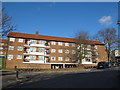
Townshend House
A four-storey block of Council accommodation on Rideout Street, Woolwich.
Image: © Stephen Craven
Taken: 19 Feb 2012
0.01 miles
2
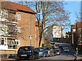
Ogilby Street
A road through a council estate in Woolwich.
Image: © Stephen Craven
Taken: 19 Feb 2012
0.03 miles
3
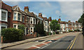
Hillreach
A terrace of 16 houses on the B210 as it curves around the grounds of the Royal Artillery Museum and the Royal Military Repository on the right.
Image: © Derek Harper
Taken: 26 Jun 2019
0.07 miles
4
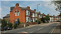
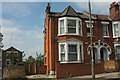
Terrace on Hillreach
Another view of the house shown in Image] and the terrace on the B210 shown in Image The terrace dates from 1898-1900. "When new these ordinary terrace houses all bore names" https://www.ucl.ac.uk/bartlett/architecture/sites/bartlett/files/48.8_cardwell_and_woodhill_areas.pdf . On the left is junction with Pellipar Road.
Image: © Derek Harper
Taken: 26 Jun 2019
0.08 miles
5
End terrace on Hillreach
The western end of the terrace shown in Image The more modern houses on the left are on Pellipar Gardens.
Image: © Derek Harper
Taken: 26 Jun 2019
0.08 miles
6
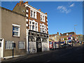
The Village Blacksmith (closed)
The former pub on Hillreach had been closed for some time when I took this photo.
Image: © Stephen Craven
Taken: 19 Feb 2012
0.09 miles
7
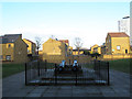
Cannon at the Red Barracks
These two cannon, along with some of the boundary walls Image, have been left as a reminder of the site's military history, though it has otherwise been developed for housing.
Image: © Stephen Craven
Taken: 19 Feb 2012
0.09 miles
8
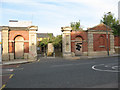
Red barracks gates
The gates, gatehouse and wall are all that remains of the former Red Barracks in Woolwich. They are grade 2 listed but on the "buildings at risk register".
Image: © Stephen Craven
Taken: 20 Sep 2008
0.09 miles
9
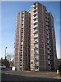
Woolwich: 71 - 177 Frances Street, SE18
One of five towerblocks built between Frances Street and Samuel Street, this one has 14 storeys and was completed in 1963. It is about 138 feet or about 42 metres high from ground level to the top.
Image: © Nigel Cox
Taken: 5 Mar 2008
0.10 miles
10
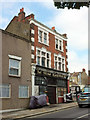
Village Blacksmith, Woolwich
Also shown in Image From https://www.ucl.ac.uk/bartlett/architecture/sites/bartlett/files/48.8_cardwell_and_woodhill_areas.pdf : "a beershop built as the Soldier’s Rest in 1842, was rebuilt in 1901–2 by Thomas & Edge".
Image: © Derek Harper
Taken: 26 Jun 2019
0.10 miles