IMAGES TAKEN NEAR TO
Pellipar Gardens, LONDON, SE18 5EG
Introduction
This page details the photographs taken nearby to Pellipar Gardens, SE18 5EG by members of the Geograph project.
The Geograph project started in 2005 with the aim of publishing, organising and preserving representative images for every square kilometre of Great Britain, Ireland and the Isle of Man.

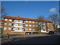
There are currently over 7.5m images from over14,400 individuals and you can help contribute to the project by visiting https://www.geograph.org.uk
Image Map
Images are licensed for reuse under creativecommons.org/licenses/by-sa/2.0
Notes
- Clicking on the map will re-center to the selected point.
- The higher the marker number, the further away the image location is from the centre of the postcode.
Image Listing (46 Images Found)
Images are licensed for reuse under creativecommons.org/licenses/by-sa/2.0
Image
Details
Distance
1
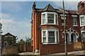
End terrace on Hillreach
The western end of the terrace shown in Image The more modern houses on the left are on Pellipar Gardens.
Image: © Derek Harper
Taken: 26 Jun 2019
0.03 miles
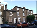
2
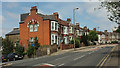
Terrace on Hillreach
Another view of the house shown in Image] and the terrace on the B210 shown in Image The terrace dates from 1898-1900. "When new these ordinary terrace houses all bore names" https://www.ucl.ac.uk/bartlett/architecture/sites/bartlett/files/48.8_cardwell_and_woodhill_areas.pdf . On the left is junction with Pellipar Road.
Image: © Derek Harper
Taken: 26 Jun 2019
0.04 miles
3
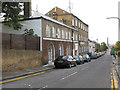
Woodrow, Woolwich
The building to the left of the picture looks 18th century in style, which if so would make it one of the oldest buildings in the area. In the distance is the dockyard chimney Image
Image: © Stephen Craven
Taken: 20 Sep 2008
0.04 miles
4
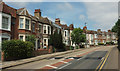
Hillreach
A terrace of 16 houses on the B210 as it curves around the grounds of the Royal Artillery Museum and the Royal Military Repository on the right.
Image: © Derek Harper
Taken: 26 Jun 2019
0.04 miles
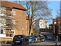
5
Townshend House
A four-storey block of Council accommodation on Rideout Street, Woolwich.
Image: © Stephen Craven
Taken: 19 Feb 2012
0.06 miles
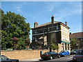
6
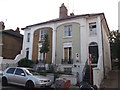
118 and 120 Woodhill, Woolwich
Pair of Grade II listed houses.
See http://www.britishlistedbuildings.co.uk/en-396777-118-and-120-woolwich for more details on the buildings.
Image: © David Anstiss
Taken: 11 Sep 2011
0.08 miles
7
Ogilby Street
A road through a council estate in Woolwich.
Image: © Stephen Craven
Taken: 19 Feb 2012
0.08 miles
8
Hillreach, Woolwich
The white stucco building with smart quoins is Hill House, numbers 51-52 Hillreach, built in about 1814-17. "The house was converted to flats in 1917–18" https://www.ucl.ac.uk/bartlett/architecture/sites/bartlett/files/48.8_cardwell_and_woodhill_areas.pdf , which details various occupants and alterations. A number 486 bus approaches along the B210.
Image: © Derek Harper
Taken: 26 Jun 2019
0.10 miles
9
153-159 Woodhill
Row of four grade II listed houses. 2 two storey houses and 2 3 storey houses.
See http://www.britishlistedbuildings.co.uk/en-396774-153-159-woolwich for more details about the buildings.
Image: © David Anstiss
Taken: 11 Sep 2011
0.11 miles
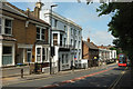
10
The Woodman pub, Charlton
A typical Victorian "street corner" pub at the top of Erwood Road, with a beer garden.
Image: © Stephen Craven
Taken: 5 Aug 2007
0.11 miles